Past IEM Features tagged: winter2324
The IEM generates per winter storm analyses of snowfall reports over Iowa and tags them by the winter season. Here are the tags used for the previous winter seasons that these maps are available for:
- Winter 2010-2011
- Winter 2011-2012
- Winter 2012-2013
- Winter 2013-2014
- Winter 2014-2015
- Winter 2015-2016
- Winter 2016-2017
- Winter 2017-2018
- Winter 2018-2019
- Winter 2019-2020
- Winter 2020-2021
- Winter 2021-2022
- Winter 2022-2023
- Winter 2023-2024
- Winter 2024-2025
- Winter 2025-2026
'23-'24 Winter Storm #16
03 Apr 2024 08:23 AMAs with other recent winter storms, we've got another difficult to measure snow producing storm impacting Iowa this Wednesday morning. The featured map attempts to analyze available NWS and CoCoRaHS reports and finds the highest totals confined to far eastern Iowa. Some of this snow fell yesterday afternoon and quickly melted. Additional snow is falling at the time of posting this featured map, so the analysis will likely be updated tomorrow when more NWS COOP reports are received. Early April snowfalls are certainly nothing out of the ordinary for Iowa and any bit of sunshine will make quick work of melting it away.
Voting:
Good: 8
Bad: 0
Abstain: 2
Tags: winter2324
'23-'24 Winter Storm #15
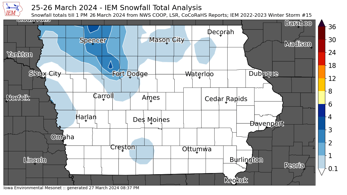
26 Mar 2024 01:13 PMAs with yesterday's map, today's attempt at a snowfall analysis has many caveats. Firstly, one may consider this snowfall as being from the same system that was included with the map for yesterday which was labelled storm 14. This map will also need regenerated tomorrow morning once more reports come in from the snow that fell Tuesday morning over northeastern Iowa. There was also an area of snow over southern Iowa that is currently under-represented with reports. The snow was also mixed with rain, with some of it melting before it could be measured! The highest totals though were confined to north and west of Fort Dodge with an isolated report of four inches. The snow won't stick around long with warmer air temperatures forecast for the rest of the week.
Voting:
Good: 2
Bad: 0
Tags: winter2324
'23-'24 Winter Storm #14
25 Mar 2024 10:35 AMThe IEM's unofficial accounting of winter storms gets to be tricky when a long duration winter storm impacts the state with much of the snow melting before once daily observations are taken. So the featured map provides an analysis of reports for the snowfall from Sunday morning with some of the light totals from NW Iowa happening perhaps on Monday. Most of the state is well above freezing this Monday with numerous rounds of showers and thunderstorms expected today. Blizzard conditions are just off to our north and west with the heaviest totals found there. This very wet storm system will be very beneficial to make up some accumulated precipitation deficits. There is an additional chance of snow from this system overnight Monday into Tuesday, so those reports may get lumped into a new storm accounting if reported accumulations warrant.
Voting:
Good: 10
Bad: 2
Tags: winter2324
'23-'24 Winter Storm #13
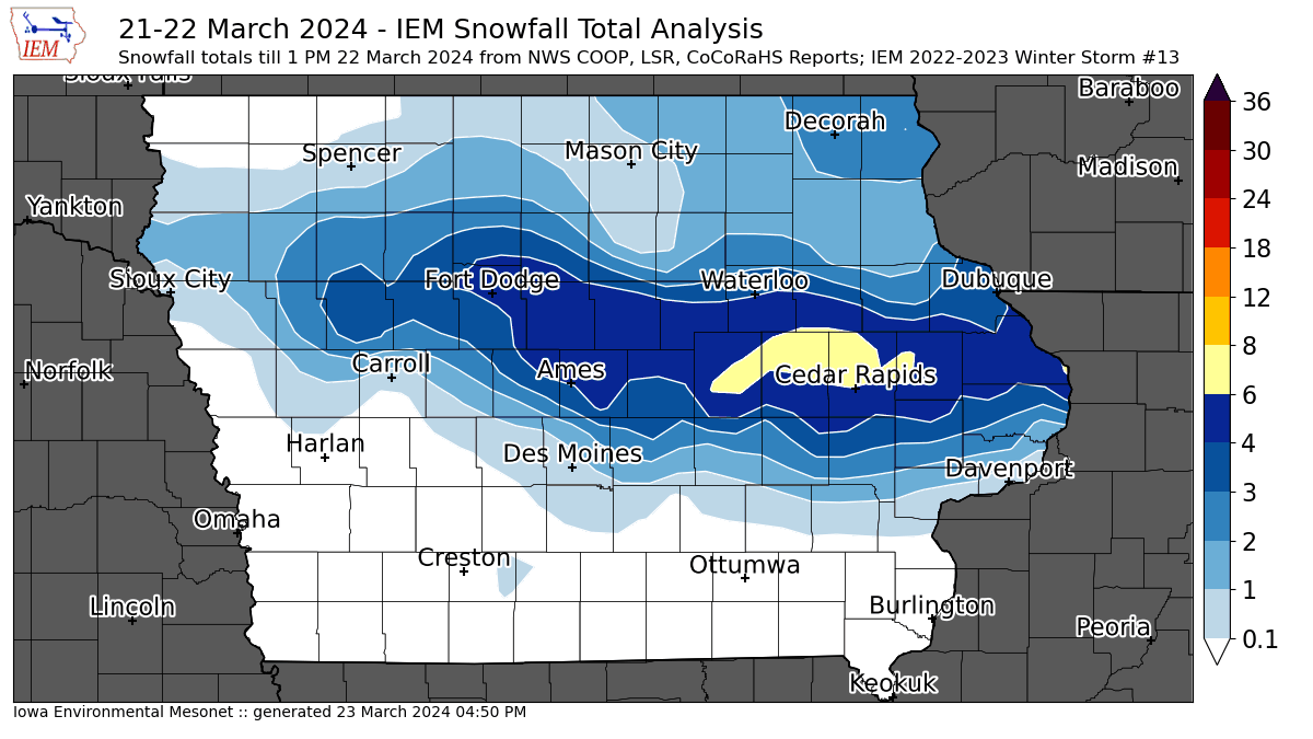
22 Mar 2024 01:15 PMA quick moving winter storm brought a downpour of moisture rich snowfall Friday morning. This was the first significant snowfall over Iowa since mid January. The featured map presents an analysis of available NWS COOP, LSR, and CoCoRaHS reports. It will be regenerated on Saturday morning once more COOP reports are received. As mentioned, the snow fell in quick fashion during the morning compute hours and created for significant travel issues. The largest totals of over six inches were found in eastern Iowa near Cedar Rapids. The gradient of snowfall on the southern end of this shown swath was very tight as temperatures were marginally cold enough to support snow and much of this area received rain and/or snowfall total robbing sleet/graupel. Our next chance of snowfall arrives Saturday night and into Sunday, but temperatures are expected to quickly rebound next week and so the snow won't stick around for too long.
Voting:
Good: 14
Bad: 0
Tags: winter2324
'23-'24 Winter Storm #12
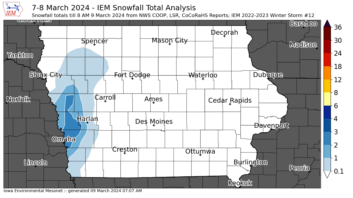
09 Mar 2024 07:08 AMWhile our most recent storm brought mostly rain to Iowa, some snow was observed over far western Iowa. A number of locations met the arbitrary threshold of two inches of snow to get an IEM snowfall map generated, so that's what is featured today. The snow that did fall was slushy and struggled not to immediate melt with soil temperatures quite warm and falling during the daylight hours. Such will be the struggle for any snow that attempts to fall with what remains of this late winter and early spring season. The forecast next week has temperatures back in well above average territory and meager rainfall chances, both of which have dominated this calendar year so far.
Voting:
Good: 9
Bad: 0
Tags: winter2324
'23-'24 Winter Storm #11
17 Feb 2024 11:59 AMThe second of two fast moving snow producing winter storms dropped a few inches of snow over Iowa Thursday night into Friday morning. The featured map presents an analysis of available NWS and CoCoRaHS reports. The largest totals approaching four inches were found over the Des Moines metro area. The snow from this event and the one from the day previous will not last long as a return to mild February temperatures begins on Sunday.
Voting:
Good: 16
Bad: 0
Abstain: 1
Tags: winter2324
'23-'24 Winter Storm #10
16 Feb 2024 05:30 AMA quick moving winter storm clipped extreme northern Iowa on Wednesday night into Thursday morning. The largest reports were found in Dickinson County of just over three inches. The main band of snow fell just north of the state with Minneapolis setting a daily record of just under seven inches on Wednesday. The next snow producing storm is already here this Friday morning and will be out of the state by afternoon. The forecast then quickly returns us to the mild weather that has dominated much of February.
Voting:
Good: 14
Bad: 31
Tags: winter2324
'23-'24 Winter Storm #9
19 Jan 2024 08:42 AMA quick moving winter storm dumped a number of inches of fluffy snow over much of Iowa on Thursday afternoon and into the evening. Having the snow fall during peak traffic hours made for some difficult travel and brisk winds were able to blow this snow around. This snowfall also added to the deep snow pack that exists thanks to the previous three storms that have yet to melt. The featured map presents an analysis of available NWS and CoCoRaHS reports. A few isolated four inch reports were found in the Des Moines and Ottumwa area. Bitter cold air and dangerous wind chills are back in time for the weekend, but the good news for those of you wishing for some melting is that above freezing temperatures are expected next week.
Voting:
Good: 19
Bad: 0
Abstain: 1
Tags: winter2324
'23-'24 Winter Storm #8
13 Jan 2024 07:53 AMThe third winter storm of this crazy winter weather week in Iowa was a big one and brought plenty of snow along with strong winds to create blizzard conditions that are persisting into today. The featured map is a preliminary attempt at a snowfall analysis from this multi-day event. Measuring snow that falls sideways is always fraught with peril and the multi-day nature of event also creates challenges to get reliable snowfall totals. So the map will be regenerated later today once more COOP and CoCoRaHS reports are received. Road conditions over the state remain horrible with blowing snow over rural areas creating impassable snow drifts. To make matters worse, the coldest air of the season has arrived and will stick around for a number of days. If there is any bright side, this is pretty much the worst that winter weather can offer in Iowa, so it is only upwards from here!
Voting:
Good: 32
Bad: 0
Tags: winter2324
'23-'24 Winter Storm #7
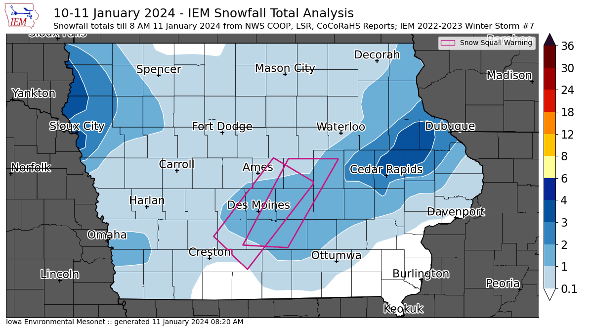
11 Jan 2024 08:28 AMWe went from having not much for winter weather to having one of the most epic winter weather weeks on record! The second snow producing storm this week brought a brief but intense burst of snowfall with a few isolated locations reporting over three inches. The quick hitting and intense burst of snow prompted NWS Des Moines to issue two Snow Squall Warnings (1, 2) Wednesday evening. These warnings attempt to cover dangerous travel impacts when road conditions become very variable due to a quick onset of intense snowfall and lowered visibility. The featured map presents an analysis of available NWS and CoCoRaHS snowfall reports along with the two polygons associated with the warnings. Attention quickly turns to a big storm arriving this evening with another round of heavy snowfall and strong winds likely combining to create blizzard conditions. Extreme cold temperatures arrive for the weekend. What a memorable week for winter weather in Iowa!
Voting:
Good: 16
Bad: 0
Tags: winter2324
'23-'24 Winter Storm #6
10 Jan 2024 08:11 AMNothing like the first big snowfall of the year perhaps being the biggest of the season! The featured map attempts an analysis of available NWS and CoCoRaHS reports. The event got started late Sunday night over far northwestern Iowa and ended Tuesday evening. Impressive snowfall totals are found over much of the state. Only far north central Iowa missed out with only a few inches reported there. A number of locations over east central Iowa ended up reporting over a foot of snow, which nicely matches the forecast map shown on Monday's Daily Feature. Road conditions remain difficult this Wednesday morning, but winds have slackened so to reduce blowing snow concerns.
Voting:
Good: 25
Bad: 0
Abstain: 1
Tags: winter2324
'23-'24 Winter Storm #5
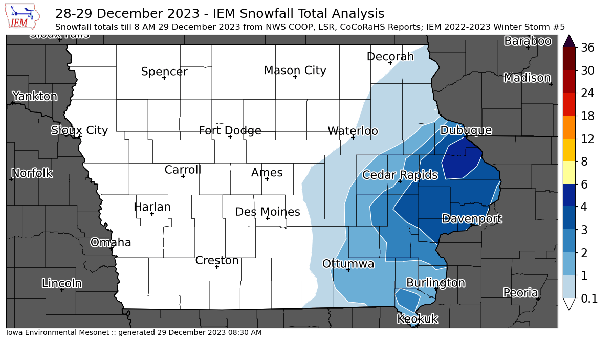
29 Dec 2023 08:35 AMAn area of snow moved into Iowa from the east on Thursday and brought a good bit of snow from Dubuque to Davenport with isolated amounts near five inches. The featured map presents an analysis of available CoCoRaHS and NWS reports. Temperatures were near the freezing point for this event, so that helped to reduce travel issues.
Voting:
Good: 10
Bad: 1
Tags: winter2324
'23-'24 Winter Storm #4
28 Dec 2023 07:13 AMIowa mostly missed out on the major winter storm on Christmas Day and afterwards that brought blizzard conditions to Nebraska. Since then, a number of periods of light snow, sleet and some drizzle has impacted a number of locations in the state. Given the prolonged period and difficulties with measurement while melting is occurring and the holiday season, the featured map just lumps all these events into one "storm" and attempts to show where the highest totals were found. Those locations being southern and far western Iowa. Will likely update this map again later today once some more reports are received from this morning.
Voting:
Good: 11
Bad: 1
Tags: winter2324
'23-'24 Winter Storm #3
03 Dec 2023 08:32 PMWhile not much of a winter storm, a passing system did dump upwards of two inches over extreme northeastern Iowa over Saturday evening into Sunday morning. The featured map provides an analysis of available NWS and CoCoRaHS reports. Another quick and light dusting of snow is expected Monday afternoon and evening over northeastern Iowa. Warmer weather is in the forecast this week, so any of the snow from these two systems will not last long.
Voting:
Good: 13
Bad: 1
Tags: winter2324
'23-'24 Winter Storm #2
26 Nov 2023 09:56 AMA snow producing storm arrived just in time for many's trip home for the Thanksgiving weekend. The featured map presents an analysis of available NWS and CoCoRaHS snowfall reports through mid morning Sunday. A bit more snow may fall today, so will likely update the map later today once more reports are received and the snow stops falling. Unfortunately, winds will be increasing today and likely to create some travel issues due to blowing snow. For those that don't want this snow to stick around, the good news is that warmer temperatures are forecast for later this week,
Voting:
Good: 16
Bad: 1
Tags: winter2324
'23-'24 Winter Storm #1
29 Oct 2023 11:20 AMThe IEM Daily Feature produces a map analysis of received snowfall reports from the NWS and CoCoRaHS when there's at least a report of two inches and/or significant impacts. These storm events are counted over the season and you can find previous year's maps here with an archive back to the winter of 2010-2011. So today we have our first map and it shows a stripe of up to four inches from the Sioux City area and off to the northeast. Additional snow is attempting to fall this Sunday over southern Iowa, but is unlikely to add up to much and so there's not likely to be an IEM map/storm generated for that event.
Voting:
Good: 16
Bad: 0
Abstain: 1
Tags: winter2324

