Past IEM Features tagged: winter1920
The IEM generates per winter storm analyses of snowfall reports over Iowa and tags them by the winter season. Here are the tags used for the previous winter seasons that these maps are available for:
- Winter 2010-2011
- Winter 2011-2012
- Winter 2012-2013
- Winter 2013-2014
- Winter 2014-2015
- Winter 2015-2016
- Winter 2016-2017
- Winter 2017-2018
- Winter 2018-2019
- Winter 2019-2020
- Winter 2020-2021
- Winter 2021-2022
- Winter 2022-2023
- Winter 2023-2024
- Winter 2024-2025
- Winter 2025-2026
'19-'20 Season Snowfall Total
01 Jul 2020 05:25 AMWith the summer time heat and humidity settled in for July, perhaps a cool thing would be to plot up the previous winter season's snowfall total thanks to an analysis provided by the National Operational Hydrologic Remote Sensing Center (NOHRSC). For most of the state, season snowfall totals were not all that impressive. Only after a major snow producing storm in April did the totals over southern Iowa start to approach or exceed season average. For me, the strong seasonality that Iowa experiences with hot summers and cold winters makes it fun to live here. For some others, I suspect they'd like either the cold or the warmth to stick around all year!
Voting:
Good: 14
Bad: 0
Tags: winter1920
'19-'20 Winter Storm #29
17 Apr 2020 07:50 AMUpwards of a foot of fluffy snow has fallen over portions of southern Iowa as shown by the featured map presenting an analysis of available NWS COOP and Local Storm Reports along with CoCoRaHS reports. This remarkable late season event fell with very little wind and created very picturesque scenes. Pavement temperatures remained warm, so the travel impacts from this snowfall were not significant. Another remarkable part of this event will be how quickly it is forecast to melt with much of it not surviving today.
Voting:
Good: 18
Bad: 0
Tags: winter1920
'19-'20 Winter Storm #28
16 Apr 2020 04:22 AMIt appears we are not done yet with snow producing storms this season as round one of snowfall yesterday dumped upwards of four inches over parts of southern Iowa. This same area is expected to get more snowfall today into tomorrow with even larger totals expected. This is all thanks to an expansive area of cold air that is dominating much of the eastern US. Much warmer weather is expected this weekend, so all of this snowfall will be short lived.
Voting:
Good: 11
Bad: 0
Tags: winter1920
'19-'20 Winter Storm #27
13 Apr 2020 07:59 AMNothing like having a big winter storm for Easter! The featured map presents an analysis of available NWS COOP, Local Storm Reports, and CoCoRaHS reports. This analysis generally culled the sleet reports which were common over much of the state. There was enough sleet to report accumulated totals even, but the reports were too sparse to make a good analysis here. Over six inches of snow was reported over far northern Iowa with totals quickly dropping off as you travel south. This week will feature some chilly temperatures for mid April.
Voting:
Good: 9
Bad: 0
Tags: winter1920
'19-'20 Winter Storm #26
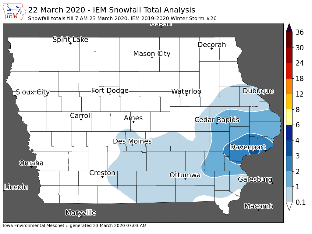
23 Mar 2020 07:08 AMWhile not much of a winter storm, the snowfall on Sunday did bring measurable amounts to southern Iowa with the heaviest totals over two inches confined to the Davenport area. These types of snow events are difficult to get reliable snowfall totals from as the snow melts before getting measured the next day. The forecast this weeks looks rather crummy with plenty of clouds and chances of rain and snowfall. Maybe it is good weather if most everyone is stuck inside anyway.
Voting:
Good: 8
Bad: 4
Tags: winter1920
'19-'20 Winter Storm #25
20 Mar 2020 07:27 AMThe weather on Thursday was certainly some of the wild weather one expects in Iowa during spring. The evening featured a somewhat rare combination of having a Tornado Watch active over southern Iowa with a Winter Weather Advisory active over northern Iowa. The featured map shows a smoothed analysis of available NWS and CoCoRaHS snowfall reports. The heaviest totals were confined to far northwestern Iowa with an isolated report of four inches received. Lighter amounts were to be found elsewhere in the state with much of the snow melting as it hit the ground. Much colder air has arrived this Friday and is freezing up the recent rain and melted snow causing some travel difficulties over northern Iowa.
Voting:
Good: 15
Bad: 0
Tags: winter1920
'19-'20 Winter Storm #24
15 Mar 2020 12:23 PMIt had been a while since our last snow accumulating winter storm in Iowa. The featured analysis is a bit of a struggle due to sparse reporting and a snowfall on Saturday that mostly melted by the day's end. The heaviest totals were found over far northwestern Iowa with generally an inch or less over the rest of the state. These late season snow falls generally struggle to stick around long as ever increasing solar angle, day length, and warming soil temperatures conspire to melt the snowfall away.
Voting:
Good: 9
Bad: 0
Tags: winter1920
'19-'20 Winter Storm #23
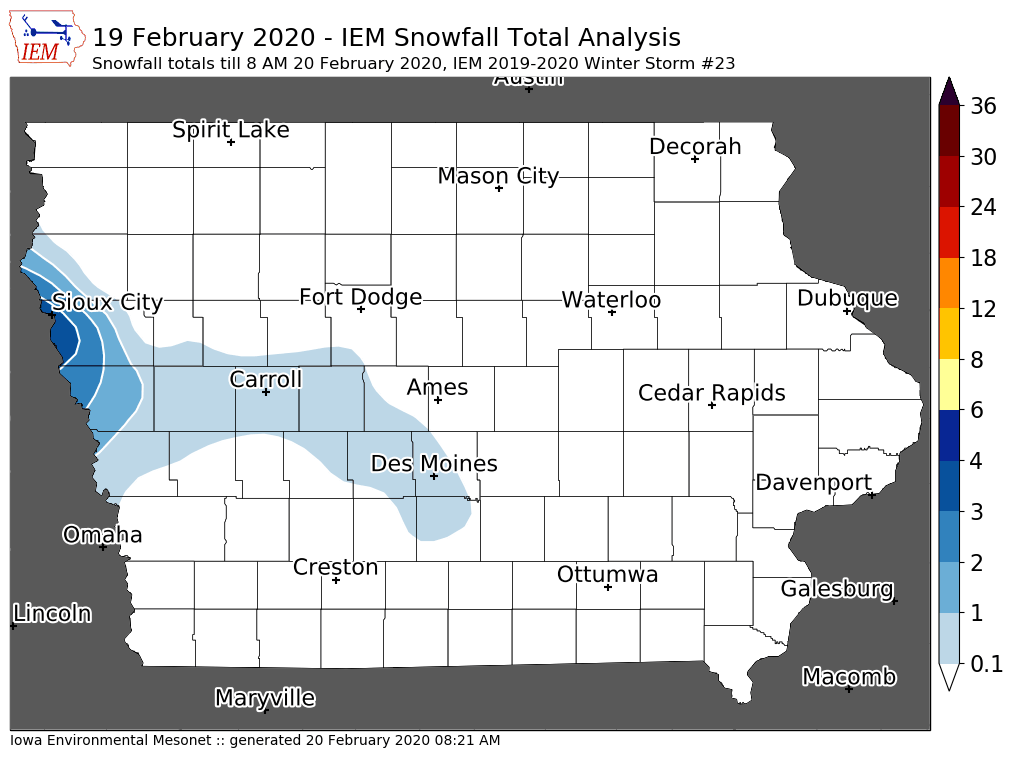
20 Feb 2020 08:21 AMWhile it was not much of a winter storm, it did bring a decent amount of snowfall over isolated parts of west central Iowa. The featured analysis of available reports likely smooths these reports out a bit too much due to the available reports in the area. Sioux City reported over five inches from the event, which was the largest report received so far. Warmer weather is in the forecast, which should quickly melt this snowfall away.
Voting:
Good: 11
Bad: 102
Abstain: 11
Tags: winter1920
'19-'20 Winter Storm #22
18 Feb 2020 08:06 AMOur most recent winter storm produced a bit more rain than snow over much of the state, but temperatures were cold enough over far northern Iowa to pick up a significant snowfall. Higher snowfall reports over four inches were reported just across the border into Minnesota and Wisconsin. Colder air worked into the state overnight and created a mess over northern Iowa as the slushy snow and rain have frozen creating icey travel conditions. We will have a few days of cold temperatures before mild air arrives again for the weekend.
Voting:
Good: 10
Bad: 0
Tags: winter1920
'19-'20 Winter Storm #21
14 Feb 2020 07:53 AMMother Nature is offering a chilly start to this Valentine's Day Friday. The arctic air poured into the state behind the most recent snow producing winter storm that impacted Iowa Wednesday night into Thursday. The featured map shows an analysis of available NWS and CoCoRaHS snowfall reports. The highest totals over Iowa were confined to southeastern Iowa with a few isolated four inch reports. The good news is that warmer weather is expected for the weekend, but chances of snow arrive again next week.
Voting:
Good: 14
Bad: 0
Tags: winter1920
'19-'20 Winter Storm #20
10 Feb 2020 08:07 AMOur most recent winter storm over the weekend just clipped extreme northern Iowa with the heaviest snowfall totals. The featured map shows an analysis of available NWS and CoCoRaHS snowfall reports with the highest values nearing eight inches over far northeastern Iowa. There were some strong northerly winds briefly on Sunday on the backside of the passing storm system.
Voting:
Good: 8
Bad: 0
Tags: winter1920
'19-'20 Winter Storm #19
25 Jan 2020 04:38 PMAn active weather pattern yielded another snow and freezing rain producing storm for Iowa on Wednesday into Friday. The featured map of available NWS COOP, Local Storm Report, and CoCoRaHS reports shows most of southeastern Iowa receiving three to four inches of snow. All of this snow fell at temperatures near freezing, which created difficult removal due to high water content and overnight refreezing issues. Hopefully we will get a bit of a break from the snow producing storms over the next week or so.
Voting:
Good: 10
Bad: 0
Tags: winter1920
'19-'20 Winter Storm #18
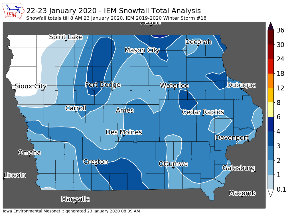
23 Jan 2020 08:44 AMThe active winter weather pattern continued on Wednesday with a slow motion dump of water rich snowfall over most of Iowa. This snow was also combined with some rain and freezing rain as temperatures hovered close to freezing. The featured map presents a smoothed analysis of available snowfall reports from the NWS and CoCoRaHS. Generally totals were three inches and less over the state. While these are "light" totals, the snow was physically "heavy" due to its high water content. More snow is falling today, but totals are not expected to amount to much for most of Iowa.
Voting:
Good: 11
Bad: 0
Tags: winter1920
'19-'20 Winter Storm #17
18 Jan 2020 08:25 AMThe active winter weather continued on Friday with a major winter storm bringing significant snowfall and even some freezing rain to the state. Blizzard Warnings are in effect today as strong winds are now blowing this snow around. Travel is not advised over much of northwestern Iowa. The featured map presents a smoothed analysis of available NWS snowfall reports so far. The map will be updated later today once more reports come in. The highest totals of six or more inches were reported just west of the Des Moines metro area and over northwestern Iowa. Much colder air will settle in for a few days behind this storm system, but above freezing temperatures are forecast later next week.
Voting:
Good: 17
Bad: 1
Tags: winter1920
'19-'20 Winter Storm #16
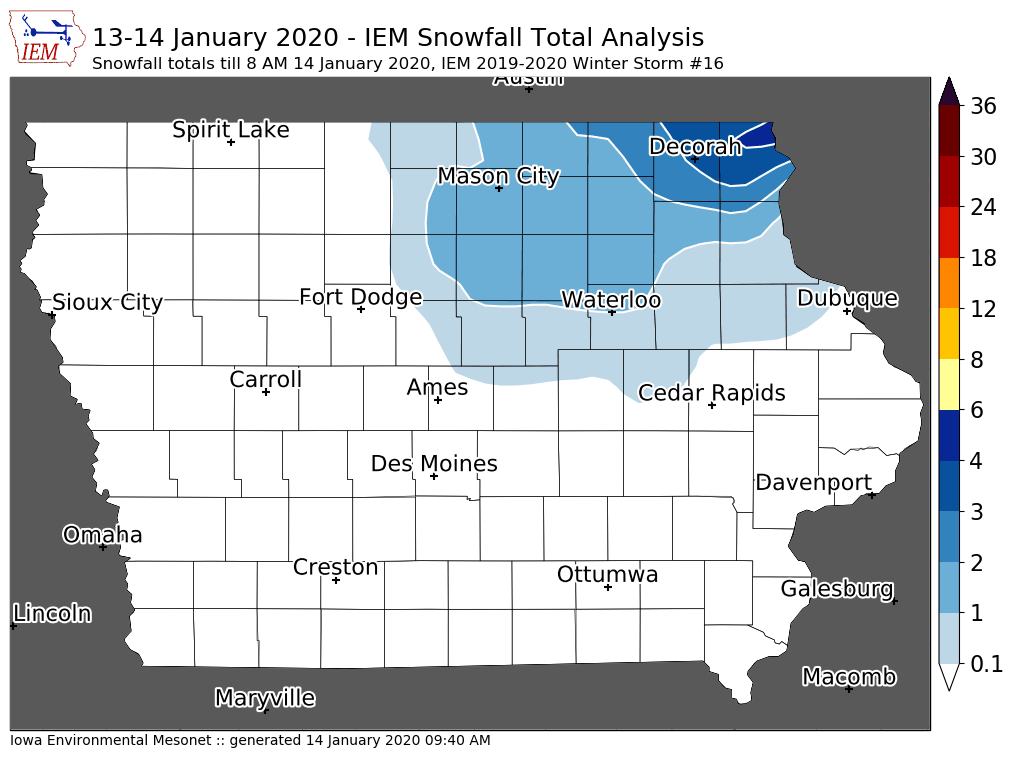
14 Jan 2020 09:44 AMOur winter storms continue at a frantic pace this week. The most recent quick hitting system dumped the heaviest totals over far northeastern Iowa. This system also brought strong winds and some freezing rain to the state making for tricky travel conditions. More storms are in the forecast this week along with much colder temperatures. We should see the coldest air of the season so far along with dangerous wind chills for the weekend.
Voting:
Good: 12
Bad: 0
Abstain: 1
Tags: winter1920
'19-'20 Winter Storm #15
13 Jan 2020 08:33 AMA quick and intense winter storm system dumped snow over Iowa on Sunday. Snowfall totals were generally a few inches or less with isolated higher amounts over northern Iowa. The featured map displays a smoothed analysis of available NWS and CoCoRaHS reports. Our active winter weather pattern will roll on this evening with a wintry mix of precipitation expected and numerous other chances of precipitation this week.
Voting:
Good: 9
Bad: 0
Tags: winter1920
'19-'20 Winter Storm #14
11 Jan 2020 10:43 AMA large and powerful storm system brought snow and rain to the state on Friday into Saturday. The featured map depicts available snowfall reports from the NWS and CoCoRaHS. It shows a stripe of two to four inches stretching from southwestern Iowa to Dubuque. The highest reported totals so far are near the Des Moines metro at about four inches. Another round of snowfall is expected this afternoon and overnight impacting southeastern Iowa.
Voting:
Good: 13
Bad: 1
Tags: winter1920
'19-'20 Winter Storm #13
04 Jan 2020 10:05 AMOur most recent snow producing winter storm packed a wallop for some parts of the state. Eight plus inches were reported in the Fort Dodge area with a very tight gradient to the south and east. Snowfall rates were intense and caused travel issues with this system. The heavy snowfall was due to an intense snow band that did not move much as the storm system pivoted over the state.
Voting:
Good: 8
Bad: 0
Abstain: 1
Tags: winter1920
'19-'20 Winter Storm #12
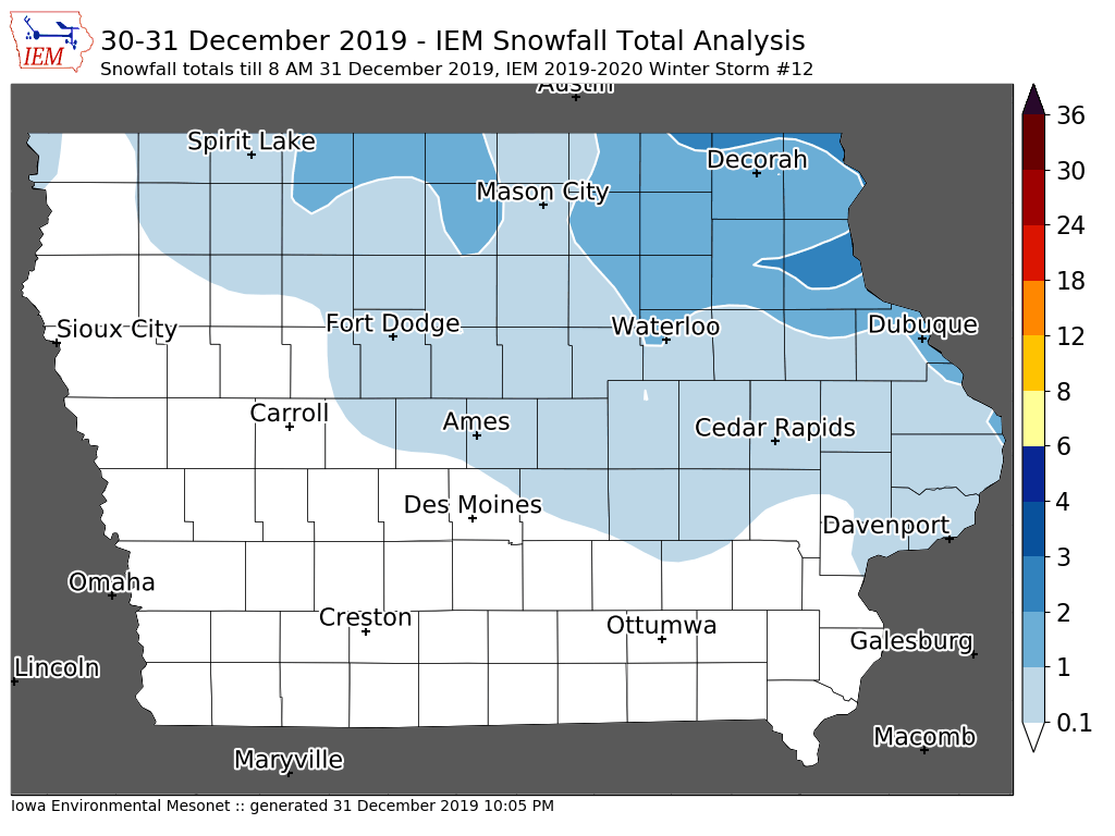
01 Jan 2020 06:46 AMHappy New Year! The round of light snowfall overnight on Monday was sufficient to reach the arbitrary threshold of having two plus inches reported somewhere in the state and so qualifies for the IEM "Winter Storm" accounting. Additionally, some may argue that this round of snow was associated with the same storm system that light snowfall over northwestern Iowa and was counted as storm #11. Anyway, have good cheer for the new year and put these worries aside! We'll have a few days of warmer weather before our next taste of winter arrives for the weekend.
Voting:
Good: 9
Bad: 0
Abstain: 1
Tags: winter1920
'19-'20 Winter Storm #11
31 Dec 2019 05:36 AMWhile the snowfall from Sunday into Tuesday might be considered all from the same storm, for these informal IEM analysis we will split them into two events. The featured map presents an analysis of the snowfall that generally ended before noon on the 30th. One to two inches of snow were common over far northwestern Iowa. Brisk winds on Monday created for some blowing snow and slight travel difficulties. The second wave this morning is dumping snow over northeastern Iowa and we'll see if it amounts to enough to warrant an additional map analysis :)
Voting:
Good: 8
Bad: 1
Tags: winter1920
'19-'20 Winter Storm #10
16 Dec 2019 09:15 AMWinter weather continues to roll with the most recent snow producing storm system mostly missing Iowa to the south, but did clip the far southern portion of the state with an inch to three inches of snow. Much higher totals were found to our south with this system with another round expected today in the area. The current forecast does have above freezing temperatures arriving later in the week with mostly quiet weather expected.
Voting:
Good: 8
Bad: 0
Tags: winter1920
'19-'20 Winter Storm #9
12 Dec 2019 05:34 AMAnother quick moving winter storm system dropped an inch or two of fluff over a swath of Iowa overnight Tuesday into Wednesday morning. An isolated three inch report was made near Waterloo. After a few week break from the snow storms of November, we are back to experiencing them rapid fire. The next system will just clip northern Iowa before the system after that brings a bit higher chance of snow to the state later this week.
Voting:
Good: 12
Bad: 0
Tags: winter1920
'19-'20 Winter Storm #8
10 Dec 2019 09:27 AMIt had been a few weeks since the last snow producing winter storm system for Iowa. While the system yesterday was small and fast moving, it caused significant traffic issues including a major pile up on Interstate 80 east of Des Moines. This system also prompted the issuance of a new-to-Iowa NWS product called the "Snow Squall Warning". These warnings cover spatially confined, brief, but intense snow squalls that create the rapidly change driving conditions. The featured map shows that snowfall amounts were very light over the state with very isolated reports of two inches over far northwestern Iowa.
Voting:
Good: 11
Bad: 0
Tags: winter1920
'19-'20 Winter Storm #7
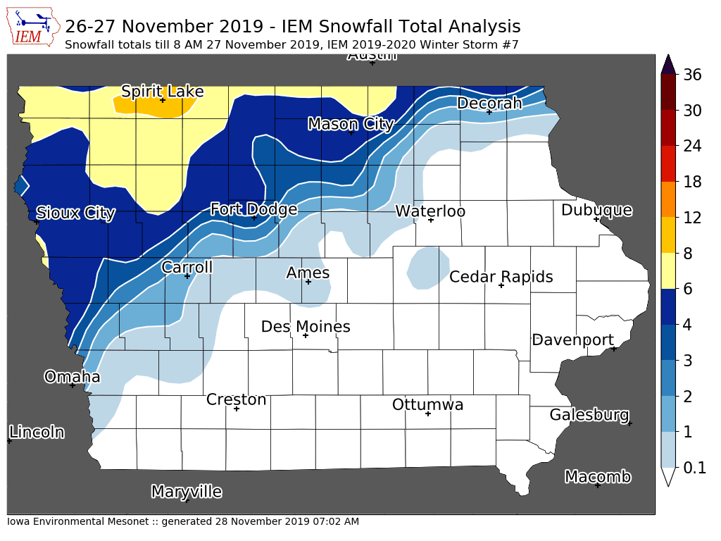
27 Nov 2019 08:09 AMJust in time for peak Thanksgiving travel, a winter storm brought significant snowfall over much of northern Iowa overnight and strong winds are howling this morning over all of Iowa. The featured map presents an analysis of available snowfall reports from the NWS and CoCoRaHS. The largest total so far is over eight inches near Storm Lake. Will update this map later today once more reports come in to help refine the analysis. Have a safe Thanksgiving travel where ever you are going!
Voting:
Good: 27
Bad: 2
Tags: winter1920
'19-'20 Winter Storm #6
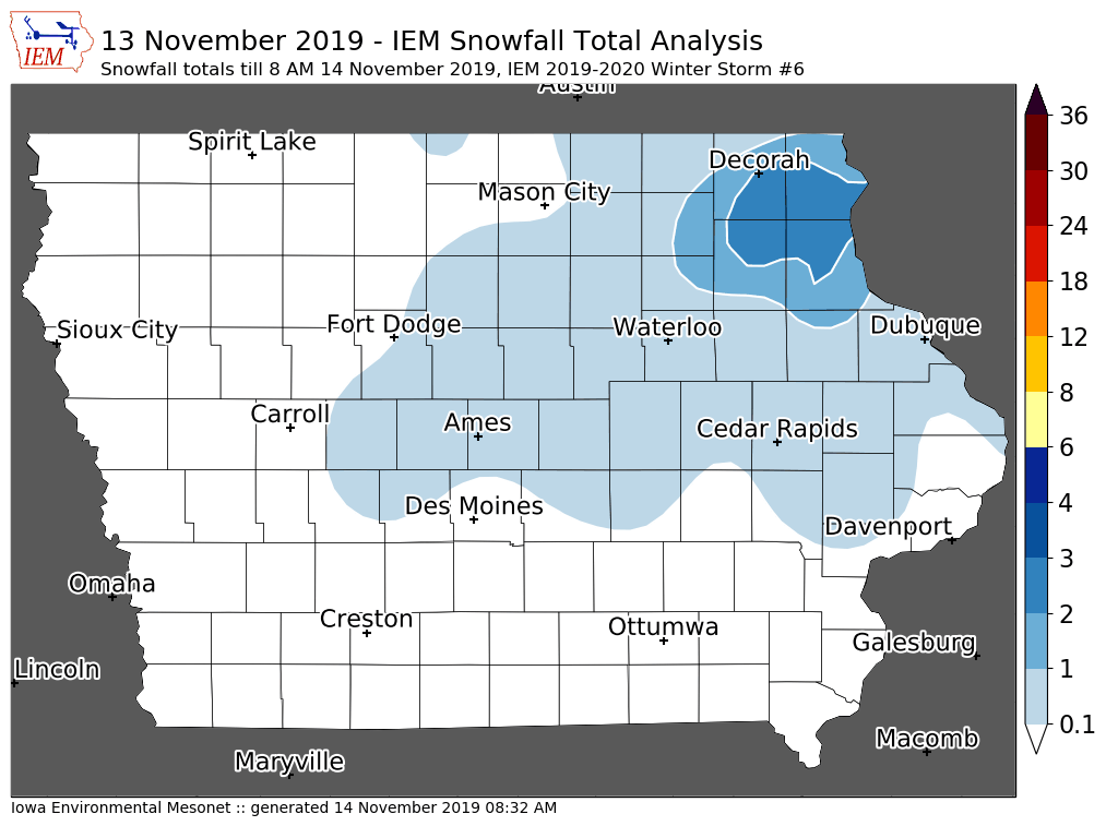
14 Nov 2019 08:38 AMThe snow producing winter storms continue at a frantic pace for early November with the most recent round barely producing two inches over far northeastern Iowa. Again, the informal metric used to compile these storm events is for at least two inches of snow reported or impactful winter weather from things like freezing rain / sleet. Could we be done with the snow storms for a while? The forecast has some optimism for this and at least has above freezing temperatures!
Voting:
Good: 12
Bad: 0
Tags: winter1920
'19-'20 Winter Storm #5
12 Nov 2019 05:33 AMThe fast start to the snowfall season continued on Monday with a good chunk of the state picking up between three to five inches. The featured chart shows a smoothed analysis with a few reports of five inches embedded within the general area of four plus inches. This snow came with bitter cold temperatures that will stick around for most of Tuesday. The good news is there is some optimism for warmer temperatures next week, but at least one more round of snow is possible before then.
Voting:
Good: 13
Bad: 2
Abstain: 2
Tags: winter1920
'19-'20 Winter Storm #4
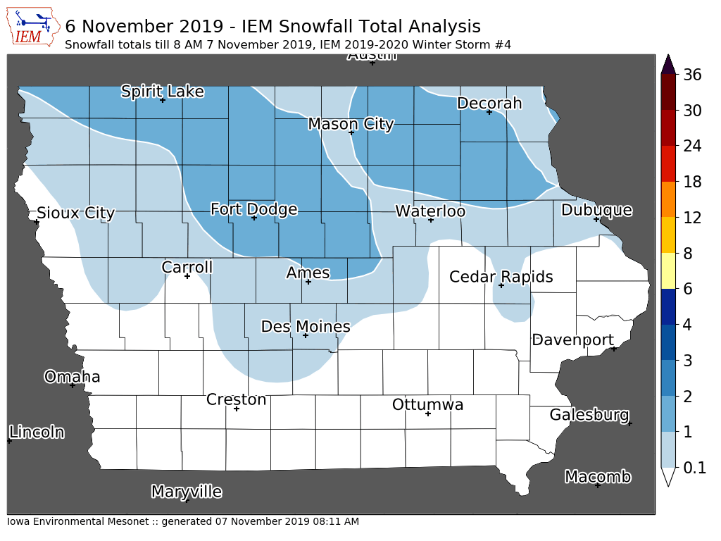
07 Nov 2019 08:16 AMA fast moving system quickly followed the snow producing storm from Tuesday night dumping an inch or two of snow over northern Iowa Wednesday afternoon and evening. Again just for some book keeping here, the IEM produces these maps for any winter system producing at least a few reports of two plus inches of snow, accumulating freezing rain, and/or significant impacts. So this system barely qualified, but there was some travel impacts as the snow was associated with a rapid drop in temperature which led to slick driving conditions.
Voting:
Good: 9
Bad: 0
Abstain: 1
Tags: winter1920
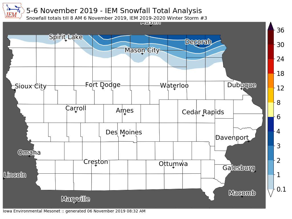
'19-'20 Winter Storm #3
06 Nov 2019 08:36 AMWe are off to a fast start this cold season with snow producing winter storm systems. The featured map displays a smoothed analysis of available NWS COOP, Local Storm Reports, and CoCoRaHS observations. Most of Iowa missed out on snowfall with this system with the largest totals confined to locations near the Minnesota border. Much colder air is working into the state today and will make for a very chilly Thursday.
Voting:
Good: 7
Bad: 1
Tags: winter1920
'19-'20 Winter Storm #2
31 Oct 2019 08:21 AMThe snow producing storm systems have been frequent this week and the most recent dump of snow brought the heaviest totals to southeastern Iowa. The featured map indicates a stripe of two to six inches over the area. It is still snowing in the area at the time of this writing, so will update the map later today once more reports come in. The snow is expected to end in the area by early afternoon. Another round of snow is expected this week, but amounts are forecast to be very light.
Voting:
Good: 16
Bad: 1
Tags: winter1920
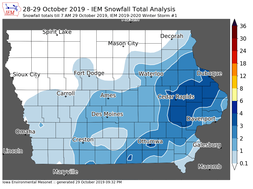
'19-'20 Winter Storm #1
30 Oct 2019 05:34 AMIt is time again to start tallying winter storms for the season! The unofficial requirement used on this website is for a system to produce at least two inches of snowfall or have significant impacts (ie freezing rain) somewhere in Iowa. The system Monday night qualifies as a good portion of southeastern Iowa received two to four inches. The featured map is a smoothed analysis of NWS COOP, Local Storm Reports, and CoCoRaHS reports. We'll have another winter storm today into Thursday with the highest amounts shifted slightly to the south and east of this most recent storm.
Voting:
Good: 14
Bad: 0
Tags: winter1920


