National Weather Service Text Product
Displaying AFOS PIL: SPSDMX
Product Timestamp: 2026-09-18 14:44 UTC
Bulk Download Help
This bulk download tool provides the NWS text
in a raw form, hopefully directly usable by your processing system.
You can either provide a complete 6-character PIL/AFOS ID or provide
the 3-character base ID (e.g., AFD). The start and end
dates represent 00 UTC for those dates. The Zip format is useful as
the filenames will have the product timestamp, which is useful for
when the product format has ambiguous timestamps.
893
WWUS83 KDMX 181444
SPSDMX

Special Weather Statement
National Weather Service Des Moines IA
944 AM CDT Fri Sep 18 2026

IAZ033-034-044>047-057>062-070>075-081>086-092>097-181600-
Sac-Calhoun-Crawford-Carroll-Greene-Boone-Audubon-Guthrie-Dallas-
Polk-Jasper-Poweshiek-Cass-Adair-Madison-Warren-Marion-Mahaska-
Adams-Union-Clarke-Lucas-Monroe-Wapello-Taylor-Ringgold-Decatur-
Wayne-Appanoose-Davis-
Including the cities of Sac City, Lake View, Odebolt, Wall Lake,
Schaller, Early, Rockwell City, Manson, Lake City, Pomeroy,
Denison, Carroll, Jefferson, Boone, Audubon, Exira,
Guthrie Center, Panora, Bayard, Casey, Perry, Waukee, Adel,
Des Moines, Newton, Grinnell, Atlantic, Greenfield, Stuart,
Adair, Fontanelle, Winterset, Earlham, Indianola, Norwalk,
Carlisle, Pella, Knoxville, Oskaloosa, Corning, Creston, Osceola,
Chariton, Albia, Ottumwa, Bedford, Lenox, New Market, Mount Ayr,
Lamoni, Leon, Corydon, Seymour, Allerton, Humeston, Centerville,
and Bloomfield
944 AM CDT Fri Sep 18 2026

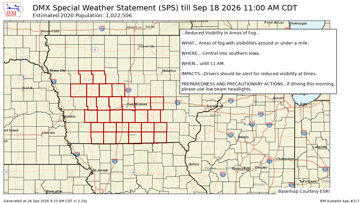
...Reduced Visibility in Areas of Fog...

WHAT... Areas of fog with visibilities around or under a mile.

WHERE... Central into southern Iowa.

WHEN... until 11 AM.

IMPACTS...Drivers should be alert for reduced visibility at times.

PREPAREDNESS AND PRECAUTIONARY ACTIONS...If driving this morning,
please use low beam headlights.

$$

Morrow/Dodson
Autoplot 217 generated the following image below. You may find more customization options , like removal of RADAR, for this image by visiting that autoplot.
