Past IEM Features tagged: severe
Showers before Afternoon Severe
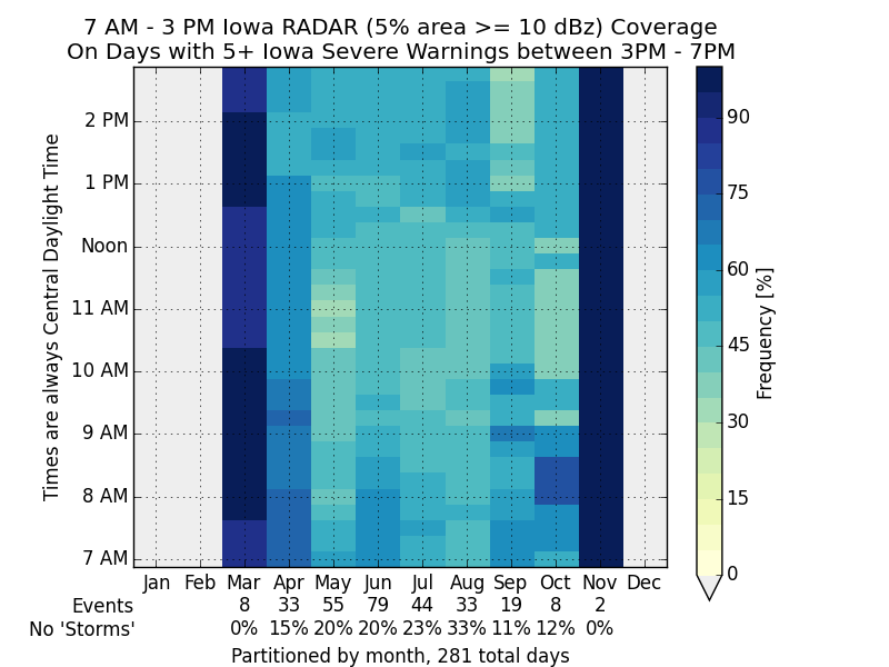
18 Sep 2015 05:35 AMThe severe weather threat forecasted for Thursday afternoon did not materialize due in part to morning storms that kept clouds around for much of the day. The featured chart attempts to look into the frequency of having showers in the state on days that have severe weather in the late afternoon. The chart presents the frequency that a given time in the morning to early afternoon has at least 5% of Iowa covered by RADAR reflectivity at or above 10 dBz (light showers). The chart is partitioned by month with the number of events and percentage of events without hitting this threshold denoted as 'No Storms'. This analysis would indicate that these severe weather events are not limited to days without showers in the morning hours. The largest non-storm values are in the summertime when larger scale forcing is the weakest and the need for solar heating is the greatest.
Voting:
Good: 25
Bad: 29
Abstain: 23
Tags: severe nexrad
Severe Season
08 Apr 2015 05:42 AMAfter an extremely quiet March, Iowa's severe weather season is getting ramped up this April with a number of NWS Offices servicing Iowa issuing their first severe thunderstorm warning this year. The featured chart displays the period between the first and last severe thunderstorm warning issued by NWS Des Moines each year. Waiting until April is not out of the ordinary for the first warning to be issued. More warnings are expected today and tomorrow as a large storm system crosses the central US.
Voting:
Good: 20
Bad: 14
Abstain: 6
Tags: severe
Quiet Start to 2015
19 Mar 2015 05:42 AMThe featured chart presents the year to date accumulated total of Severe Thunderstorm and Tornado Warnings issued by United States NWS Offices. Not only is the total for 2015 the lowest since at least 2003, it is not even close to any other year! The next closest year of 2004 is about four times greater than this year! Of course, a very active severe weather week could make up these differences, but such a week does not appear to be any time soon. Eventually the warm and muggy Gulf of Mexico air will surge northward and provide a needed ingredient for severe weather. This will also provide some needed rain as our current stretch of weather has been very dry as well.
Voting:
Good: 18
Bad: 4
Abstain: 4
Tags: 2015 severe
Precip during Severe Weather
26 Aug 2014 05:39 AMThe featured chart attempts to answer the question about how much of our yearly precipitation falls during severe weather. For this analysis, the proxy for severe weather is having an active severe thunderstorm or tornado warning active. The chart shows the absolute and relative contributions of yearly precipitation during warning events, for a period one hour before and one hour after the warning event, and then all other times. For the past decade , during which we have one minute precipitation data from the Des Moines Airport, the relative contribution ranges from about 5 to 20%. The chart average is about 10% or just over 3 inches per year.
Voting:
Good: 19
Bad: 6
Abstain: 5
Tags: severe
Wind and Hail
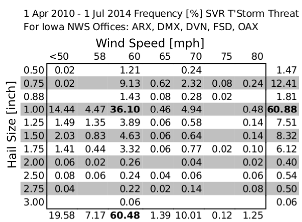
02 Jul 2014 05:39 AMWhen the local National Weather Service offices issue severe thunderstorm warnings, they include information on the magnitude of the hail and wind threat forecasted. So each warning contains expected hail size and wind speed. The featured chart presents the frequency of these threats since they were implemented in the warning product. Our most recent severe weather event on Monday had four warnings issued for 80 mph winds and seven warnings for two inch hail or larger. The hail size must be one inch diameter or larger to verify the warning. The wind speed must be greater than 58 mph for it to verify the warning.
Voting:
Good: 12
Bad: 8
Abstain: 5
Tags: severe warnings
Daily Warning Frequencies
25 Jun 2013 05:13 AMThe featured chart displays two daily frequencies of tornado and severe thunderstorm warnings in the United States. The green bars are the percentage of years since 2002 that at least one tornado or severe thunderstorm warning occurred on. The blue bars are the simple average number of total warnings issued per day. So while the number of warnings peaks in mid June, just about every day during the summer season sees severe weather somewhere in the US. In fact, this chart shows there has not been a day in July without severe weather since 2002. More severe weather is possible today in Iowa along with continued heavy rainfall events.
Voting:
Good: 83
Bad: 17
Tags: nws severe


