Past IEM Features tagged: satellite
NOAA20, Snow cover, and High Temps
27 Nov 2023 09:58 PMThe recently fallen snow cover had a significant impact on Monday air temperatures as illustrated by the featured map. The map combines NOAA20 true color imagery via NASA with NWS COOP locations reporting snow cover (blue dots) and daily high temperatures from airport weather stations. The impact of the stripe of snow over Kansas, Iowa, and into Illinois is readily apparent with warmer temperatures on either side. This snow cover is not expected to last long with winds switching to the southwest by Wednesday, allowing warmer air to advect into the state.
Voting:
Good: 20
Bad: 0
Tags: snowcover satellite
Snow Covered State
22 Jan 2021 05:48 AMWith skies finally mostly clear of clouds on Thursday, it is a good time to check in on how Iowa look's from the NASA Terra satellite. The featured map presents true color imagery taken yesterday along with morning NWS COOP snowfall depth reports. Practically the entire state is shown with some amount of snow cover. More snowfall is on the way for the weekend and into next week.
Voting:
Good: 20
Bad: 1
Tags: satellite
Retreating Snow Cover
05 Mar 2020 05:34 AMThe featured movie is a time lapse from Wednesday of GOES-16 "true color composite" imagery courtesy of the College of Dupage website. Plentiful sunshine and warm temperatures did a number on snow cover over eastern Iowa as you can visibly see the snow cover area retreat northward during the day. After a very windy day tomorrow, even warmer weather is again expected for the weekend. Will winter weather make a return yet this spring season?
Voting:
Good: 13
Bad: 61
Abstain: 5
Tags: goes16 satellite
Canadian Smoke
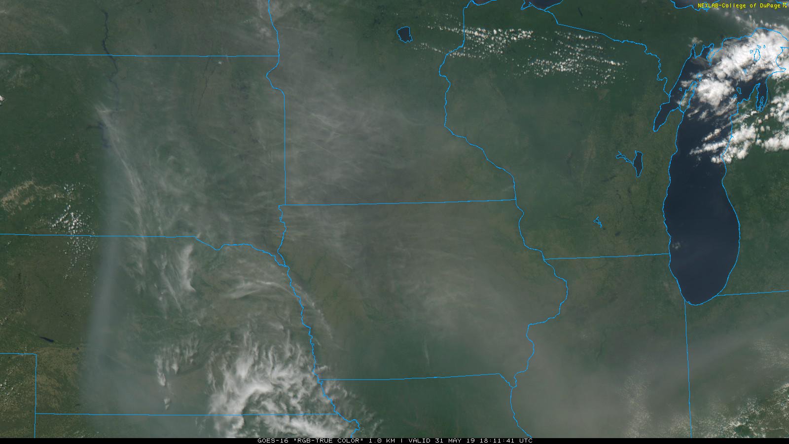
03 Jun 2019 05:34 AMThe smoke in the air this past weekend was very noticeable and easily visible from weather satellites including GOES 16 as shown by the featured map courtesy of College of DuPage. This smoke is from wild fires burning over western Canada. It thankfully mostly remained aloft over Iowa, not greatly impacting surface air quality. The hazy weather though did cut down on surface heating and likely cut a few degrees off of temperatures for the weekend.
Voting:
Good: 15
Bad: 0
Abstain: 1
Tags: satellite
Historic Missouri River Flooding
18 Mar 2019 03:43 PMThe featured image is courtesy of @CopernicusEU showing a dramatic view of the historic flooding over eastern Nebraska and western Iowa using data from Sentinel 2 satellite. For the gauge at Plattsmouth, Nebraska, the Missouri River is four feet above the previous record stage. The ongoing flooding situation is being helped by mostly dry weather this week, but there is still plenty of snow to melt yet over areas further north.
Voting:
Good: 5
Bad: 0
Tags: flood satellite
Dark Brown
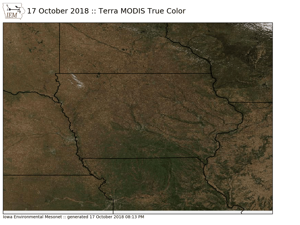
18 Oct 2018 05:37 AMIt is always fun this time of year to check in on what the satellites see of our landscape on days with a clear sky as was the case on Wednesday. The featured image is from the Terra MODIS satellite showing a true color depiction. Most of the landscape is brown and will all of the recent rains, the color is a dark brown. The current weather and near term forecast remains mostly dry, which is exactly what is currently needed.
Voting:
Good: 10
Bad: 0
Tags: satellite
Bore + Gravity Wave Clouds
20 Sep 2018 05:34 AMThe featured animation is of GOES 16 satellite imagery over Iowa on 19 September 2018. The imagery shows some neat bore / gravity wave clouds resulting from thunderstorms during the day. These clouds are a result of rain cooled air being denser and pushing south into warmer northbound flow. The animation shows these clouds dissipating with time and a general outflow boundary / warm front appear with a thunderstorm eventually fire on the boundary over southern Iowa. Due to file size constraints, this animation does not depict the highest resolution in space and time now available by this new satellite. You can find great imagery like this on the College of DuPage website.
Voting:
Good: 14
Bad: 1
Tags: satellite
Natural Snow Removal
20 Apr 2018 05:30 AMMostly clear skies on Thursday allowed the sun to do some much needed snow removal work over northern Iowa. The clear skies also allowed various satellites to monitor the progress! The featured lapse is from the GOES-East satellite from about 8 AM till 7 PM on 19 April 2018. You can easily see the snow line creep north as the snow is melted away. The snow that remained overnight is helping to create record or near record low temperatures over Iowa on Friday.
Voting:
Good: 24
Bad: 2
Tags: satellite
Large Comma
07 Mar 2018 05:34 AMThe featured animated GIF is derived from multi-channel GOES-16 (GOES East) imagery attempting to show a "true color" depiction of what you would see from space. This loop is from Monday and shows the large cloud shield in the shape of a comma with the comma head showing a discernible rotation over Iowa. This system was 'stacked', which means the surface low pressure is vertically below the upper troposphere low pressure center. This type of cloud formation is common with mature and large storm systems.
Voting:
Good: 17
Bad: 0
Tags: satellite
Head South to Find Brown
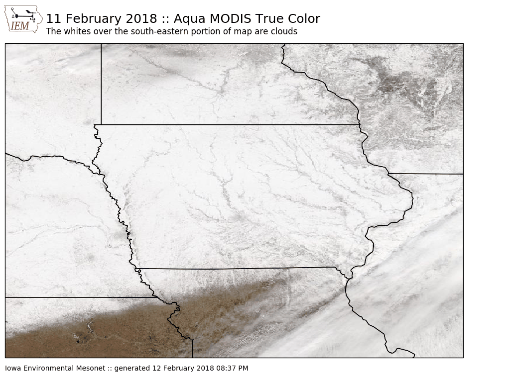
13 Feb 2018 05:33 AMThe clear skies overhead on Sunday allowed for the various satellites to get a good look at our snow covered landscape covering the state. The featured map is from the Aqua MODIS satellite showing a "true color" depicting. Note that there are some clouds over the far southeastern portion of this map, but a clear view of the snow exists over Iowa. It is interesting to see that the snow cover does not persist much farther south into Missouri. They have mostly missed out on the recent snow falls.
Voting:
Good: 9
Bad: 0
Tags: satellite modis
GOES-R
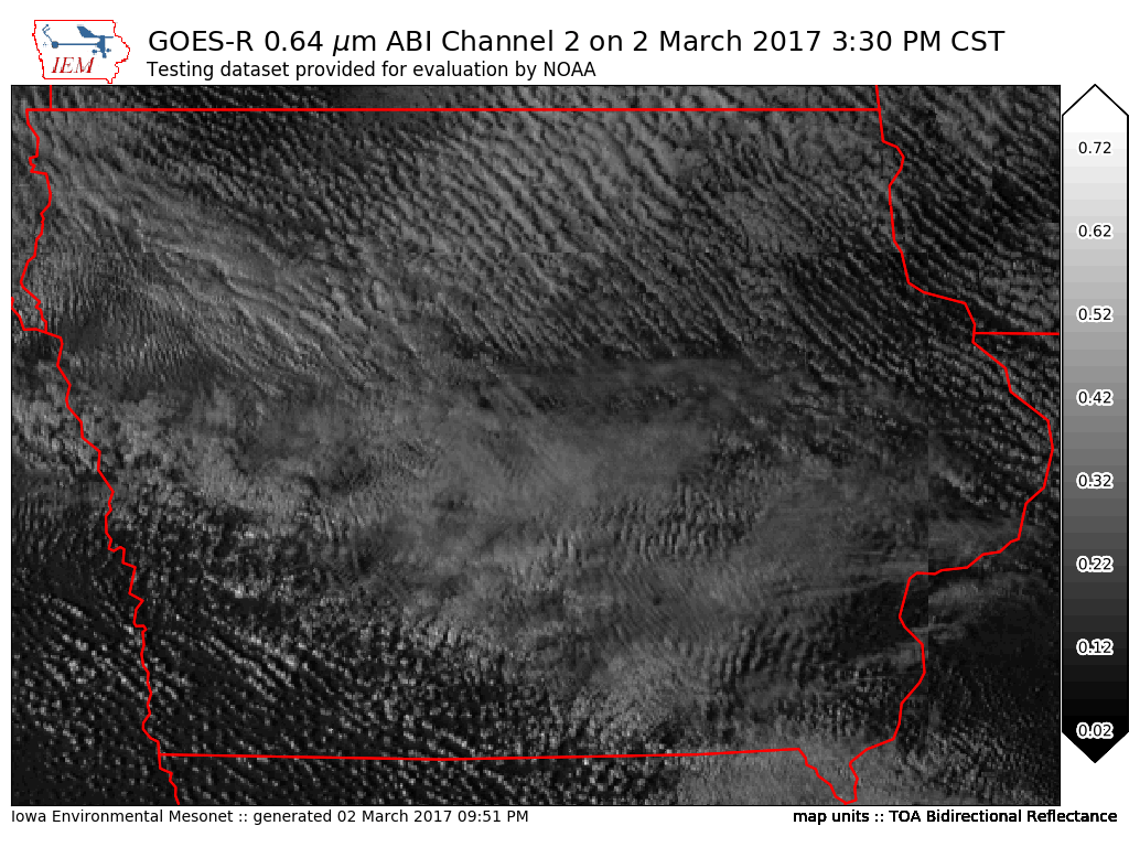
03 Mar 2017 05:16 AMFor my nearly 20 year career in the meteorology field, it is difficult to remember a period with more excitement than what currently exists over GOES-R. GOES-R is a newly launched satellite by NOAA and NASA that features far superior and more diverse imaging than what is currently operational today over the United States. On Thursday, NOAA began a wider dissemination of test and evaluation products from this new satellite. The featured map is a simple plot of GOES-R ABI channel 2 over Iowa. While this image may not look impressive, the spatial and temporal detail provided by this product will be a game changer in weather forecasting and modelling. You will undoubtedly see many spectacular loops and images from this satellite this year as it prepares for operational status in late 2017. Here is a much more impressive loop over Texas produced by CIRA at Colorado State.
Voting:
Good: 19
Bad: 0
Tags: satellite goes-r
Snow from Space
14 Dec 2016 05:35 AMA mostly clear sky on Tuesday afforded an opportunity to see the snow-scape over Iowa. The featured map is from the Terra MODIS satellite and shows much of the state covered in snow. The southwestern corner of the image is clouds. The presence of snow cover makes a big difference in daily high and low temperatures. It will be interesting to see what the snow cover looks like later this week when the really cold air arrives for the weekend. Certainly, the amount of cover won't decrease prior to then as temperatures remain well below freezing.
Voting:
Good: 15
Bad: 0
Tags: satellite
Sunny and Snow Covered Saturday
04 Jan 2016 05:09 AMClear skies on Saturday allowed for a good look from the Terra MODIS satellite at our current winter landscape in Iowa. Practically the entire state is shown covered in snow with the river channels and reservoirs clearly visible. The warm temperatures in December have left the larger reservoirs mostly ice free.
Voting:
Good: 21
Bad: 11
Abstain: 8
Tags: satellite
Just SW corner snowfree
23 Nov 2015 05:42 AMThe first significant snow storm of the season brought upwards of a foot of snow for portions of northern Iowa. Amounts decreased as you travel south in Iowa. The featured map displays Aqua MODIS True Color imagery for yesterday and shows that snow currently covers all but the far southwestern corner of the state. Warm temperatures are expect this week, which should melt a majority of the recent snowfall in the state.
Voting:
Good: 23
Bad: 6
Abstain: 4
Tags: satellite
Smoke Swirls
11 Jul 2015 05:48 AMVisible satellite imagery on Friday morning captured swirls in the smoke plume from Canada. These swirls are always present in the atmosphere, but we often can not see them in the cloud formations. Much like how people use tracers in a wind tunnel to see how the air is flowing, the smoke plume was doing a similar thing in the atmosphere.
Voting:
Good: 25
Bad: 11
Abstain: 5
Tags: satellite smoke
View from space
13 Jan 2015 05:41 AMIt is always a good idea to check in on how we look from space. With clear skies overhead on Monday, the Terra MODIS satellite true color image shows the snow covered landscape over Iowa. Just the southwestern corner of the state is free of snow at the moment. After cold conditions today, temperatures are forecasted to approach 40 degrees by the weekend.
Voting:
Good: 19
Bad: 4
Abstain: 1
Tags: satellite
Greener than 2012
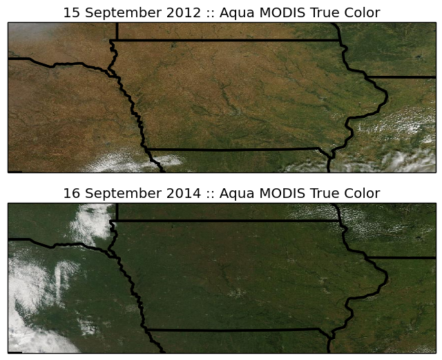
17 Sep 2014 05:46 AMClear skies on Tuesday provided the Aqua MODIS satellite an unobstructed view of Iowa's landscape. The featured chart compares the MODIS true color product for yesterday with a close date from 2012. The weather for 2012 was nothing like what has happened this year with 2012 being hot and dry while this year has been cool and wet. The agricultural crops still need more heat units to reach maturity this year and so that explains the obvious difference in greenness.
Voting:
Good: 21
Bad: 7
Abstain: 5
Tags: modis satellite
Greener than Last Year
26 Sep 2013 05:35 AMIt is always fun to look at MODIS satellite true color imagery when there are no clouds in the sky. The featured image compares the Aqua MODIS true color image from this year and last on 23 September. The difference in color is noticeable with 2012 much browner than this year. While both years experienced a drought, last year had record warmth and this year had a cooler summer with a late spring planting date. The effect is that many fields are still green this year as the crops have not reached maturity. This is why avoiding a freeze is so important as the crops need more time.
Voting:
Good: 47
Bad: 7
Tags: satellite
Dust Storm
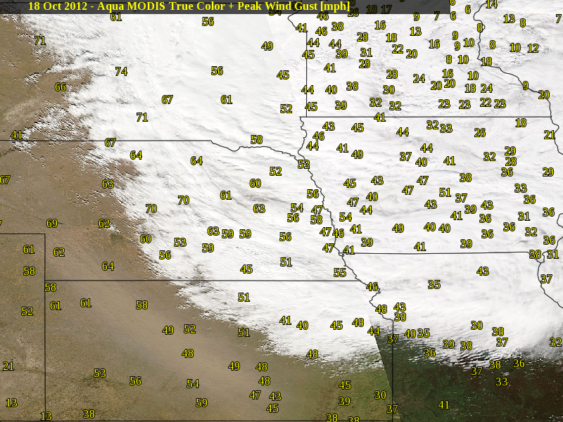
19 Oct 2012 04:29 AMWith a number of comparisons being made of this year to the years of the Dust Bowl Era (1930s), it only makes sense that a full blown dust storm visit the plains states now as well. A very large storm system generated a large area of strong winds on Thursday and kicked up a bunch of dust from Nebraska to Oklahoma. The featured image shows the combination of peak reported wind gust along with a true color image from the Aqua MODIS satellite. You can see the streak of brown just outside of the cloud shield from the storm complex. Peak winds were well above 50 mph and even reached 75 mph in some select locations.
Voting:
Good: 46
Bad: 16
Tags: satellite dust
Snow Destruction
27 Feb 2012 05:51 AMA strong wind and warm temperatures over this past weekend made for quick work of much of the snow that fell last week over Iowa. The featured image simply shows the difference between late Saturday morning and Sunday afternoon from the MODIS satellites. Our next storm system arrives this evening with the heaviest snowfall expected to stay to our north.
Voting:
Good: 17
Bad: 5
Tags: satellite
Snow and clear skies
13 Feb 2012 05:53 AMIt is always fun to check out satellite imagery on clear sky days in the winter time. The featured image shows Terra MODIS true color satellite imagery with high temperatures on Sunday. Having snow cover on Sunday made the difference between having a high temperature slightly below freezing to one that was a bit above freezing. Our next winter storm is here this morning with snowfall totals expected to not amount to much.
Voting:
Good: 22
Bad: 6
Tags: satellite
Snow and no snow
16 Jan 2012 05:48 AMThe high temperature you experienced on Sunday in Iowa was very dependent on the amount of snow you received from our storm last week. Warm air surged into the state, but thanks to snow cover over eastern Iowa temperatures were much cooler than the mid 50s over western Iowa. This contrast is nicely shown by overlaying high temperatures on Sunday to visible imagery showing areas with and without snow. The forecast for this week looks to be active with another warm up expected next weekend.
Voting:
Good: 25
Bad: 5
Tags: snowcover satellite
White on Brown
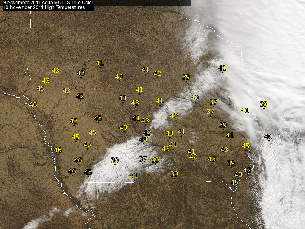
11 Nov 2011 07:11 AMHaving clear skies after a new snowfall always makes for pretty pictures from space like the one featured today. The new snow cover also makes for interesting local weather effects as can be seen by afternoon high temperatures on Thursday. The snow reflects much of the sun's energy back out into space which keeps air temperatures cooler than neighboring snow free areas. This snow patch should continue to decrease in size with more above freezing temperatures expected.
Voting:
Good: 29
Bad: 6
Tags: satellite
From green to brown
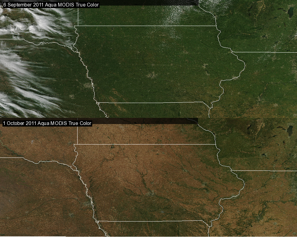
03 Oct 2011 05:56 AMClear skies overhead this weekend give satellites a great look at the ground to show what has happened to our landscape over the past month. The featured image is of Aqua MODIS true color imagery from 6 September and 1 October of this year. Our lush green landscape has been replaced by the brown shades of fall. This color change is important as it changes the albedo of the surface allowing warming to occur more rapidly. This change will be in effect this week with mostly clear skies expected to push temperatures to near 80.
Voting:
Good: 22
Bad: 7
Tags: satellite
Ugly scar
26 Aug 2011 05:53 AMBesides dumping heavy rainfall last week, a cluster of powerful thunderstorms dropped large hail over parts of southwestern Iowa last Thursday. A week later and a clear sky overhead allowed the Terra MODIS satellite to get a good look at the result of the hail storm. These hail scars are easily visible given the contrast of green crops and the hailed on areas whose green leaves were stripped away exposing the brown ground. The featured image combines the satellite image with NWS collected reports of hail size on the 18th.
Voting:
Good: 33
Bad: 8
Tags: satellite hail
Smokey Clouds
09 Jun 2011 05:48 AMVisible satellite imagery from Wednesday afternoon shows the eruption of storms over eastcentral Iowa. It also shows smoke plumes from the wild fires over the southwestern US (the fuzzy striations). These storms formed along a front that ushered in much drier and cooler air. Large hail and strong winds were reported from some of these storms.
Voting:
Good: 26
Bad: 10
Tags: satellite
Nary a cloud in the sky
17 May 2011 05:53 AMAfter a miserable weekend, Monday was very nice with clear skies and warmer temperatures. There was also abundant dry air which makes for good conditions for satellites to peer down at us and capture beautiful shots such as the featured image from MODIS. Another clear day is expected today!
Voting:
Good: 14
Bad: 4
Tags: satellite
A good match
14 Apr 2011 05:48 AMA few days ago, the total rainfall for April was featured showing a swath over the state that has missed out on the heavier rains (first image). A group here at ISU is working with a satellite called SMOS that attempts to sense the moisture in the upper few inches of soil. The SMOS soil moisture percentage is presented in the second image. The patterns line up very nicely where the areas that have received rains have wetter top soils than other areas. You may think this to be obvious, but having two independent datasets agree with each another is an encouraging sign and hope that the satellite is providing quality information. This plot has implications for spring farm field work as the upper top soil needs to be somewhat dry to support heavy equipment transversing it. Look for more SMOS information to appear on the IEM soon!
Voting:
Good: 28
Bad: 1
Tags: satellite smos
Kicking up dust
08 Oct 2010 05:54 AMThe featured image shows a comparison between the morning and afternoon MODIS true color satellite imagery on Wednesday. If you look closely, the afternoon imagery has a light vale overlain. The imagery is showing all of the dust being kicked up by the intense agricultural harvest activity ongoing. The continued dry and warm weather is allowing the rapid progress to be made and saving farmer's money by lowering crop drying costs as the ambient air is very warm already! High temperatures today are expected to be in the lower 80s!
Voting:
Good: 47
Bad: 13
Tags: satellite
Landscape turns to brown
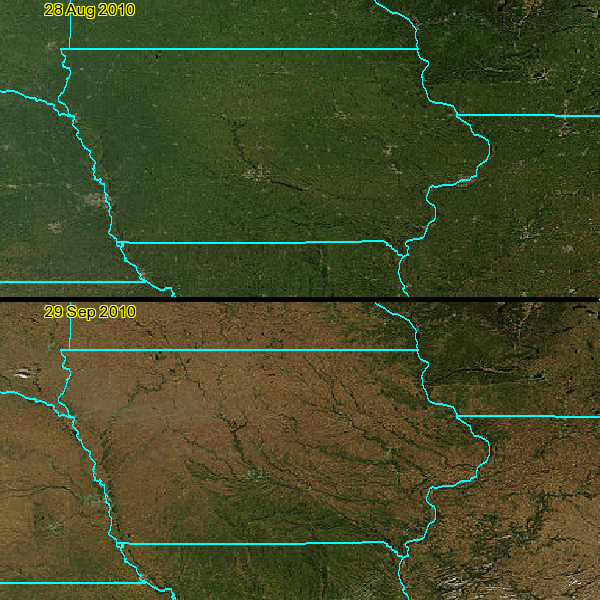
30 Sep 2010 05:54 AMThe featured image shows a comparison between a Terra MODIS satellite image from last month and yesterday. The landscape has gone from a lush green to a dull brown, which is a good thing since it means the agricultural crops are drying up to support their harvest. This change also has an implication for how effectively the sun is able to warm the surface up (albedo). Maybe in another month or two this comparison would show the landscape turning white, but lets enjoy the fall season first!
Voting:
Good: 38
Bad: 3
Tags: satellite
Dry air helping out
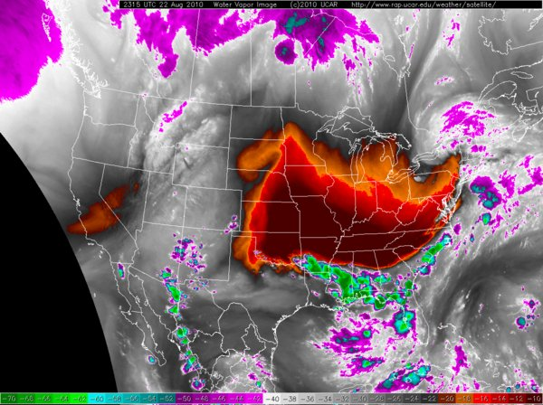
23 Aug 2010 05:21 AMThe featured map is a NOAA satellite's water vapor channel imagery from Sunday afternoon. The dark reds in the imagery indicate dry air thanks to a large ridge parked over the central US. This dry and warm air overhead helped to suppress storm development, which is exactly what we needed. An interesting and technical discussion of this unusally dry air over the central US can be found on the CIMMS Blog.
Voting:
Good: 32
Bad: 7
Tags: satellite
Engulfed Iowa
02 Jun 2010 05:16 AMThe featured infrared satellite image is from Tuesday evening showing Iowa covered by a cloud shield produced from a mesoscale convective system (MCS). This storm system brought heavy rain, big hail, and even a few tornados to the state and it continues to exist this Wednesday morning. This type of storm complex is common for Iowa during the summer time and the frequently occur during the night time as warm and moist air from the Gulf of Mexico is pumped north.
Voting:
Good: 32
Bad: 5
Tags: satellite
Quick melt
22 Mar 2010 05:05 AMLonger days and ever increasing solar angle give snow very little chance of surviving this time of year. The featured satellite image is from different times on Sunday showing the decrease in snow coverage in Southwestern Iowa. More melting will occur today with springlike weather expected for the week.
Voting:
Good: 32
Bad: 9
Tags: satellite
All wrapped up
12 Mar 2010 06:11 AMA very large storm system has its center of rotation parked over the state on Thursday. The featured visible satellite image and 10m AGL wind barbs were valid at noon on Thursday and show the very pretty counter clockwise flow. The surface low pressure center is still over the state this morning, but is quickly dying to make way for the next storm system set to arrive.
Voting:
Good: 44
Bad: 18
Tags: satellite
Engulfed in snow
05 Mar 2010 06:14 AMBesides feeling the warm sunshine, a benefit of having clear skies during the daytime are the cool images satellites can take of our snow covered landscape. An Aqua MODIS satellite image from Thursday is featured showing the entire state covered in snow. The NASA website has images at a higher resolution where you can easily see cities and roads. Warmer weather and rain this weekend will eat away at this snow field with some flooding impacts expected early next week.
Voting:
Good: 66
Bad: 17
Tags: satellite
Another Hail Scar
13 Aug 2009 06:08 AMA few weeks ago, the result of a significant hail storm in Northeast Iowa was featured by showing the impact on vegetation. Another major hail storm left a similar scar over Central Iowa on Sunday and its effect can be seen as well. The featured image transitions from the Terra MODIS imagery to NEXRAD maximum reflectivity composite. Like with the previous feature, you can see the correlation between the highest reflectivites and the damage on the ground.
Voting:
Good: 20
Bad: 5
Tags: satellite nexrad hail
Impressive Hail Damage
30 Jul 2009 12:14 AMLast Friday, an extremely strong thunderstorm complex dropped a bunch of large hail over NE Iowa and SW Wisconsin. The NWS has an excellent summary of this event here and here. The featured image is a combination of Terra MODIS satellite for yesterday and maximum NEXRAD reflectivity for the event. The area shown initially in gray is unfortunately massive crop damage as the green leaves were shredded by the large hail and the area no longer appears to be lush green from space. You can see the streaks in the damage as the storms moved off to the southeast.
Voting:
Good: 39
Bad: 3
Tags: hail nexrad satellite
Snow and high temps
07 Apr 2009 06:18 AMThe featured image is yesterday afternoon visible satellite imagery and high temperatures. The snow field left from Sunday's storm was a mere county or two wide. The effect of this snow cover can easily be seen with high temperatures warmer on both sides of the snowpack. If you click on the image, there are low clouds shown over Southern Iowa.
Voting:
Good: 22
Bad: 6
Tags: satellite
Snow did not last long
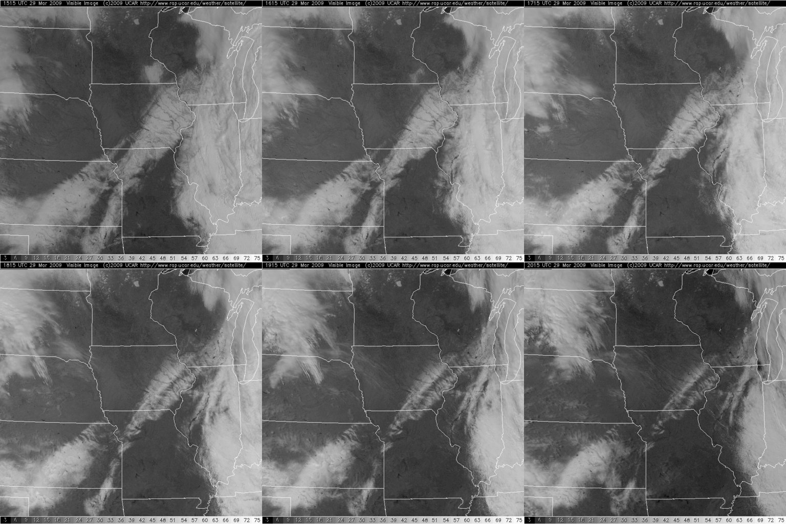
30 Mar 2009 06:11 AMAfter the snow stopped falling on Sunday morning, the skies cleared and the sun made quick work of removing a good portion of what fell. The featured animation is visible satellite imagery from Sunday showing the initial snow cover quickly melt away. Unfortunately, another storm will bring snow to the state on Tuesday.
Voting:
Good: 31
Bad: 4
Tags: satellite
More interesting patterns
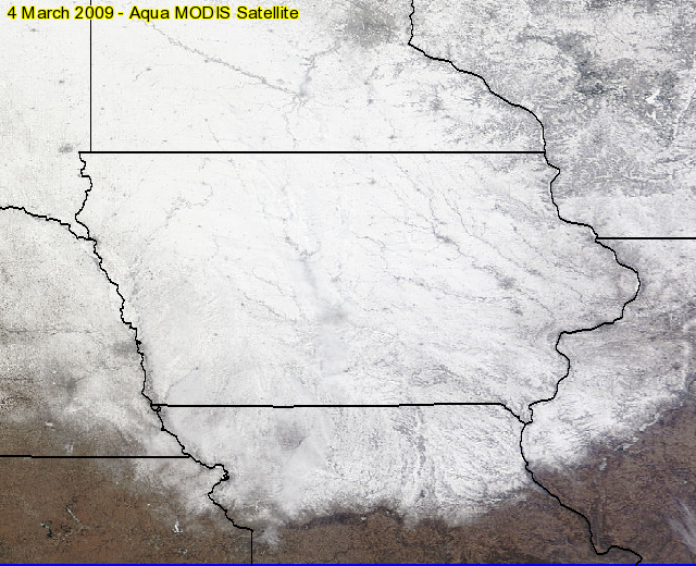
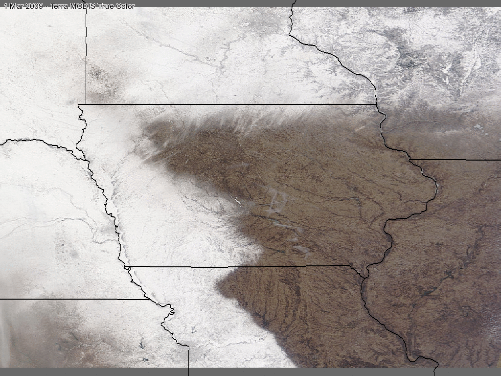
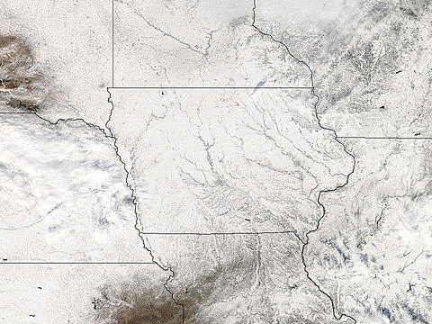
03 Mar 2009 06:16 AMJust a few weeks ago we featured a belt of snow visible from the Terra MODIS satellite. Two snow storms later, we have another interesting pattern shown in today's feature with the western and northern borders of the state covered. Warmer weather for the rest of this week should melt a good portion of this snowfield.
Voting:
Good: 21
Bad: 5
Tags: satellite
Belt of snow
16 Feb 2009 06:12 AMThe stretch of warm weather last week left a snow-free slate for the snow storm on Friday to place a pretty pattern over the state. The featured image is a true color composite from the Terra MODIS satellite on Sunday showing the belt of snow laid down from the storm.
Voting:
Good: 32
Bad: 5
Tags: satellite
A thin line
31 Dec 2008 06:20 AMVisible satellite imagery from Monday shows a curious line stretching from near Lamoni to Decorah. When the skies are cloud free, visibile satellite imagery can see snow and ice accumulations on the ground. This particular line was generated from a brief snowfall on Saturday that fell behind the area of freezing rain.
Voting:
Good: 32
Bad: 12
Tags: satellite
Some bare patches
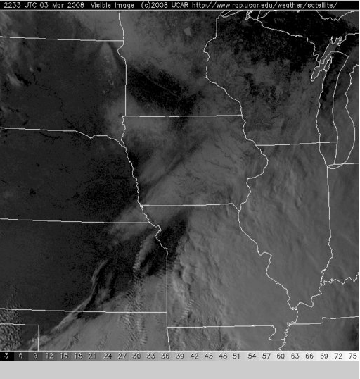
04 Mar 2008 07:17 AMVisibile satellite imagery from late in the afternoon on Monday nicely shows the snow that has been covering our landscape for the past 3 months. There are some locations in the state without snowcover and you can see those areas in black. Looping the visible satellite imagery on warm and sunny days will often show the snow field contracting. Let us hope for a lot of that!
Voting:
Good: 20
Bad: 8
Tags: satellite
Lunar Landscape?
19 Dec 2007 06:52 AMCan you guess what this picture is of? ... It is a rectified true color image taken from the MODIS Aqua satellite yesterday over Central Iowa. You can see Des Moines, Ames, Boone, and Saylorville Lake in the image! If you look closely, you can also see roads appearing in this 250 meter resolution image. Of course, the entire landscape is covered in snow and ice making it almost look like something you would see on the moon. You can get more images like this one on the MODIS Rapid Response System website which generates a pretty image each day for Iowa.
Voting:
Good: 21
Bad: 5
Tags: satellite
Happy weather?
10 Oct 2007 12:08 AMThis infrared satellite image was taken early Tuesday morning showing an interesting cloud formation over Minnesota :) This is associated with an upper level low that is helping to push very cool air into our area with highs on Wednesday only expected in the 50s! Temperatures are expected to return to the 60s by this weekend, which is about normal for this time of year.
Voting:
Good: 33
Bad: 10
Tags: satellite
Our weathermaker
01 Jun 2007 07:02 AMThe featured map is a top-down water vapor estimation from the GOES satellite. These plots are used for many purposes including a simple way to see the motions of the atmosphere. There is a large upper level low system over the Dakotas (swirl in image) that will slowly move east today. Counterclockwise flow around this system will help to fire thunderstorms in Iowa today and this weekend.
Voting:
Good: 25
Bad: 14
Tags: satellite
March in like a herd of lions!
01 Mar 2007 06:23 AMA massive storm is cranking up this Thursday morning with heavy snowfall rates reported in Western Iowa and severe thunderstorms all the way south to the gulf coast. This storm system is still strengthening as it lifts northeast over Iowa. A blizzard warming is posted for most of Western Iowa with the heaviest snow totals exceeding a foot!
Voting:
Good: 30
Bad: 10
Tags: satellite
Lake Low
14 Feb 2007 04:03 AMAn interesting small scale phenomena occured over Lake Superior on Tuesday. The featured loop is of visible satellite images, notice the counter clockwise swirl? This swirl is a result of very cold air settling over the open lake water. The warmer and saturated air over the lake quickly rises forming shallow clouds and over time organizes into a circulation you can see on satellite. A larger time lapse can be found here. The COMET MetEd site has a much more detailed explaination of this phenomena.
Voting:
Good: 30
Bad: 6
Tags: satellite
Des Moines River snowfall
09 Feb 2006 07:41 AMTuesday night's snowfall left an interesting footprint on Iowa. Visible satellite imagery from Wednesday nicely shows the band of snow following the Des Moines River. There are more chances of light snowfall thru Saturday, so we will be vigilant for other interesting snow patterns!
Voting:
Good: 17
Bad: 5
Tags: satellite
Visible Snow Line
20 Dec 2005 07:41 AMVisible satellite imagery from Monday afternoon clearly shows the division of the state into snow and snow free. You can also see the rivers snaking through the snowy areas. The snow line will be on the retreat to the northeast this week as warmer air is working into the state.
Voting:
Good: 12
Bad: 4
Tags: satellite
Streaks of snow
23 Feb 2005 08:48 AMThe snowfall from Monday night was very light, but left an interesting pattern over Iowa. The image (click to get a high res view) was taken yesterday from the MODIS satellite and shows the streaked nature of the snowfall from Monday. Most locations only reported around 1 to 2 inches of snowfall from this storm. Thanks to Scott Bachmeier (UofWisc) for sending this picture along
Voting:
Good: 7
Bad: 3
Tags: satellite
-81°C
16 Jun 2004 08:00 AMThis image was passed along to the IEM by the NWS. The image shows a satellite depiction of cloud top temperatures. The dark pixel is a -81°C reading! Such a cold reading is a sign of a very deep and vigorous convection. The storms during the past few nights have been more efficient rain than severe weather producers.
Tags: satellite
Pesky Stratus
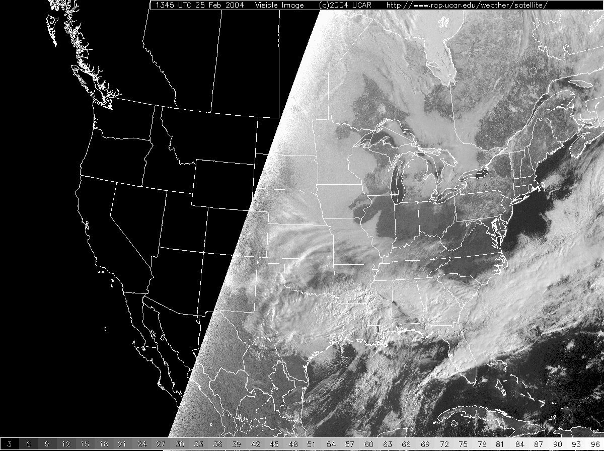
25 Feb 2004 08:16 AMAn annoying deck of low stratus has prevented our temperatures from warming these past few days. There is hope that this deck will start to erode and allow much warmer temps with the help of the sun.
Tags: satellite
Snowless Belt
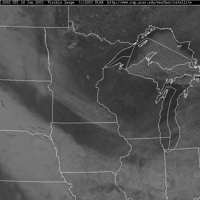
17 Jan 2003 06:53 AMShown is a visible satellite image from yesterday afternoon. With clear skies, visible imagery is able to indicate areas of snow cover. The black belt running NW to SE in the state of Iowa is an area that has missed out on the two snow storms affecting the state. Without the influence of snow, this area was about 5-10 degrees warmer yesterday afternoon than the snow covered areas.
Tags: satellite


