Past IEM Features tagged: derecho
July 15 Derecho
17 Jul 2024 05:30 AMThe storm complex from Monday afternoon into evening has been classified as a derecho by the Storm Prediction Center. The featured lapse combines NWS RADAR, Warnings, and Local Storm Reports between 3 PM and 1 AM Tuesday. The bottom panel attempts to illustrate the persistence of significant wind gust reports with each report having a five minute plot width. You can see that the line was producing consistent wind gusts reports for much of the evening hours. Additionally, EF1 rated tornadoes were confirmed within the Des Moines Metro and Davenport as well.
Voting:
Good: 12
Bad: 0
Tags: derecho
July 15 Possible Derecho
16 Jul 2024 05:23 AMThe severe weather threat on Monday materialized as forecast with a cluster of strong storms developing mid afternoon over central Iowa and then congealed into a damaging line of storms that plowed east. At the time of this feature writing, this system has yet to be a labelled a derecho, but it seems likely that it met the criteria of duration and areal coverage. The featured map presents NWS Local Storm Reports of thunderstorm wind gust and damage. As with many storms this year, this system appeared to produce a number of brief tornadoes as well making the event even more dangerous. NWS offices will be out surveying the damage today and the IEM has a Google Group you can subscribe to for email alerts when they issue damage survey reports.
Voting:
Good: 18
Bad: 0
Tags: derecho
August 10 2020
10 Aug 2021 02:29 AMIt has been a year. A year since most every Iowan learned what the term "derecho" meant and now knows not to ever want to experience one again. Derechos have hit or clipped the state a number of times in the past with the previous benchmark event happening in 1988. The 10 August 2020 far eclipsed that event and is currently considered the most costly severe thunderstorm event in US history totaling 11 billion dollars in damage. The featured lapse presents IEM generated composites of NWS RADAR along with NWS watches and warnings for the event in Iowa. You can find an excellent summary of the derecho on Wikipedia. Cedar Rapids was the hardest hit community with the tree damage cleanup recently ending 11 months after the derecho hit!
Voting:
Good: 17
Bad: 1
Abstain: 1
Tags: derecho
Derecho Power Hit
15 Aug 2020 04:25 PMThe featured graphic is a comparison between the Suomi NPP / VIIRS satellite imagery between July 29th and August 11th. The particular band shown from the satellite is good at showing city lights during clear sky conditions at night time. The damage swath from the August 10th derecho is easily seen with the bullseye hit to Cedar Rapids well shown. Power restoration work is ongoing with full restoration expected to take weeks. See this NASA Website for a better view.
Voting:
Good: 13
Bad: 0
Tags: derecho 2020derecho
75 MPH Gust
14 Aug 2020 06:00 AMThe derecho from Monday should provide fodder for the IEM Daily Feature for the foreseeable future! Today's plot presents one minute interval wind observations from the Des Moines Airport weather station. The chart shows minute by minute readings of wind speed and direction (two minute average of five second samples) and wind gust (peak 5 second sample reading). The quick rise in wind speed is readily seen with the peak value of 50 MPH sustained with gusts to 75 MPH shown. Wind gusts over 50 MPH were observed for over a twenty minute period!
Voting:
Good: 21
Bad: 1
Tags: derecho 2020derecho
The Derecho of 2020
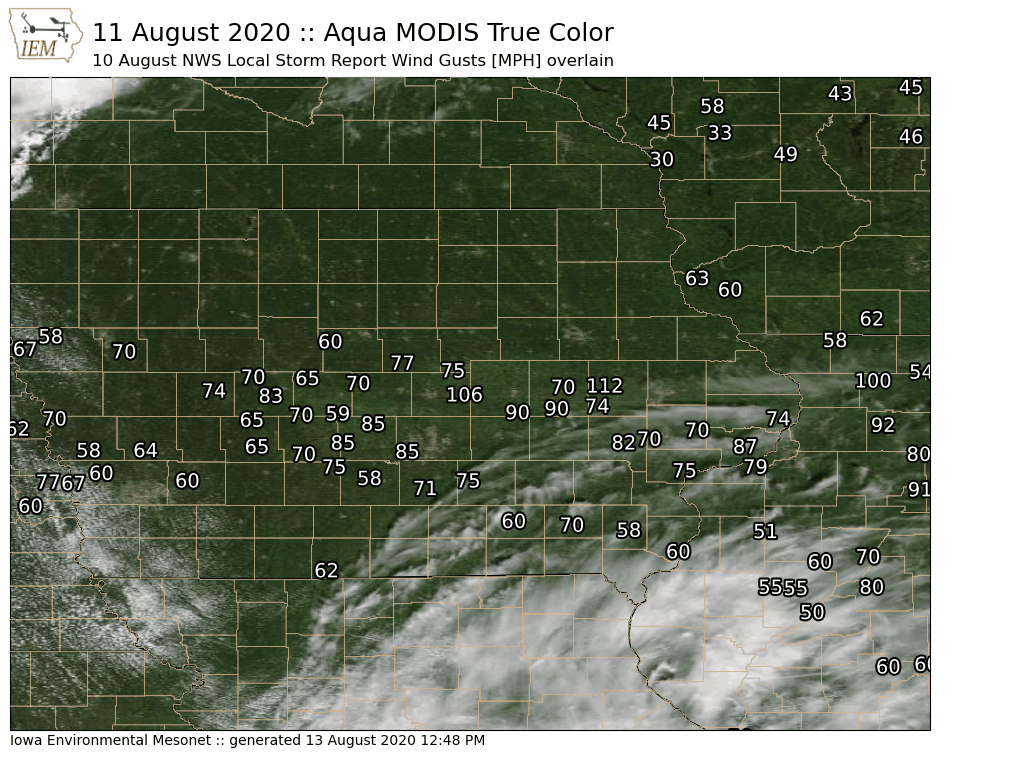
13 Aug 2020 12:58 PMOne of the most significant weather events in Iowa's history happened on Monday, 10 August 2020. A powerful complex of storms bulldozed the state and impacted the major urban centers of Des Moines, Cedar Rapids, Iowa City, and Davenport. The Aqua MODIS satellite data from Tuesday featured in today's map has been making the rounds on the Internet. The map clearly shows the extensive crop damage that happened from west of Des Moines to Davenport. We continue to await a more cloud free day to further see the extent of the crop damage from satellites. Overlain on the map is Local Storm Reports of wind gusts from the National Weather Service.
Tags: derecho 2020derecho
Ring of Fire Derecho
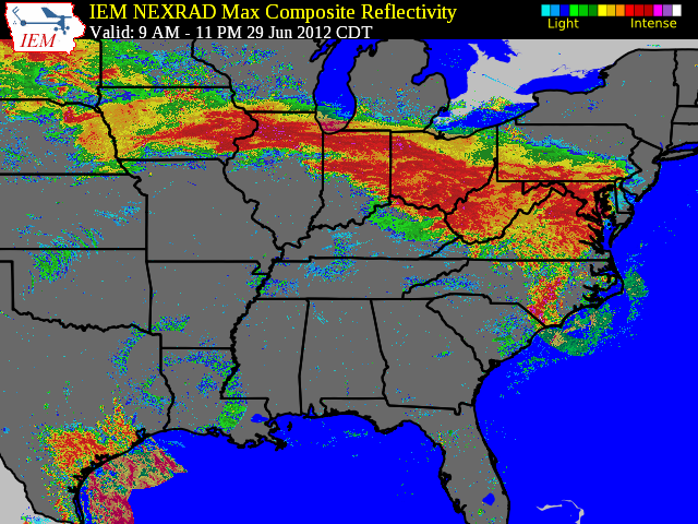
30 Jun 2012 05:47 AMYesterday's daily feature noted the extreme instability that existed in the atmosphere, but the lack of forcing to realize all that potential energy. On Friday morning, a storm cluster was able to get organized over Illinois and trucked it all the way to the eastern coast producing hundreds of reports of wind damage and should easily meet the derecho classification. The featured image shows a time composite of maximum NEXRAD reflectivity for the event. You can see the path this storm system took as it moved along the classic 'ring of fire' setup with an extremely strong high pressure system to its south. Another cluster of storms got going over Iowa Friday afternoon and caused damage in eastern Iowa. These storms are able to create their own cold air mass at the surface and then push it along providing the lift necessary to realize the available potential energy.
Voting:
Good: 114
Bad: 29
Tags: derecho ringoffire


