Past IEM Features tagged: clouds
Clouds and First Sub 29°F
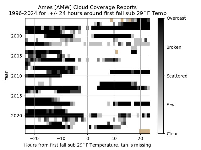
17 Oct 2024 05:30 AMWith a strong surface high pressure system overhead, temperatures cooled nicely on Wednesday morning with most of the state experiencing the first freeze of the fall season. The Ames airport bottomed out to 24°F! The featured chart presents a time series of Ames airport cloud coverage reports for a +/- 24 hour period relative to the first fall sub 29°F reading. Each pixel represents an hourly report with tan values indicating missing data. It is very interesting and intuitive to see the lack of cloud cover near the occurrence of such a cold temperature. It is a testament to the importance of radiational cooling for such events as clouds act as the proverbial blanket to buoy near surface air temperatures during night time hours.
Voting:
Good: 9
Bad: 0
Tags: firstfreeze clouds
Clouds vs without clouds
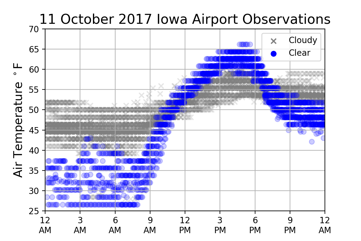
08 Dec 2020 05:37 AMThe featured chart presents air temperature observations from the Iowa airport weather stations on Monday. The dataset is partitioned by the reported presence of clouds and beautifully illustrates the impact of cloudiness on temperature. For those locations that experienced clear skies yesterday, temperatures nicely warmed during the afternoon hours and also cooled during overnight hours. While clouds reflect solar energy during the day and limit daytime heating, they act as a blanket during the night time and retransmit long wave radiation from the surface back to the ground thus limiting cooling.
Voting:
Good: 12
Bad: 0
Tags: clouds
Clouds influencing temperature
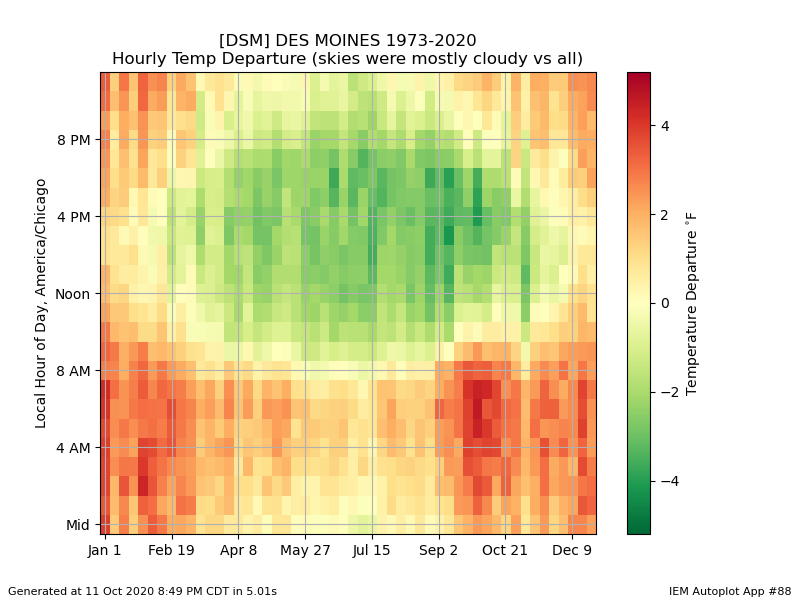
12 Oct 2020 05:39 AMThe presence of clouds this time of year can make a significant difference for the air temperature near the ground. The featured chart presents the hourly difference by week of the year for the air temperature when clouds were present versus the average for all cloud coverage amounts. The chart nicely shows a strong diurnal and annual signal. Some of the largest positive departures can be found during the early morning hours this time of year. Clouds help trap heat near the ground and thus buoy temperatures during night time hours. The effect is negative during the daytime as clouds reflect solar energy, preventing it from heating the ground and subsequently the near ground air.
Voting:
Good: 11
Bad: 1
Tags: clouds
Done with Gloom Soon?
22 May 2020 04:57 AMThe recent lack of sunshine and associated chilly temperatures is starting to get old. This gloomy weather has included plenty of time with overcast skies and low cloud ceilings. The featured chart presents a histogram of overcast skies and at what level those reports occur at using period of record observations from the Ames Airport. There are caveats galore with this plot including important quirks with how the ceiling readings are reported by automated sensors. The y-axis scale is also logarithmic to better detail the low level conditions. The point of the plot is the frequency of low clouds and generally overcast conditions starts to decrease by the end of May. Warmer soil temperatures, increasing solar inputs and warming lower atmosphere all help to mix the boundary layer and relegate clouds to higher levels. The forecast has at least warmer temperatures, but still appears to keep gloomy conditions around for a few more days at least!
Voting:
Good: 16
Bad: 1
Abstain: 2
Tags: clouds
Plenty of Clouds
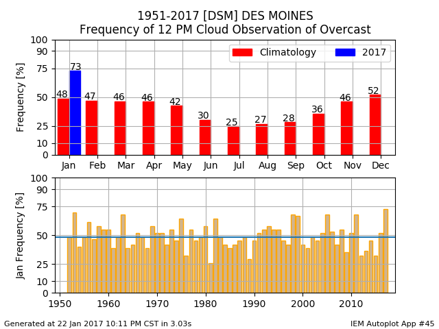
29 Jan 2020 05:34 AMTuesday was yet another day in the stretch of cloudy, foggy, freezing drizzle, and light snow days this January. The featured chart looks the cloudiness aspect of this month with the percentage of days that had overcast conditions reported at noon for Des Moines. The total this month is shown against a simple long term average on the top panel with the bottom panel comparing each of the Januaries on record. The percentage this year is well above average, but still a bit behind that of just three years back in 2017. With the forecast of three more cloudy days to go, we may come close to beating that total.
Voting:
Good: 12
Bad: 0
Tags: clouds
Clear Skies and Temps
17 Dec 2018 05:33 AMFor those without snowcover, temperatures warmed very nicely over the weekend into the 40s and even briefly the 50s for a lucky few. Those with out snow were likely crediting the clear skies for allowing sunshine to warm us up, but the impact of clear skies on temperature is not straight forward this time of year. The featured chart presents the temperature difference between when skies were reported clear versus the period of record observations by week of the year and local hour of the day. The chart shows that having sunshine has the largest warming during the warmer half of the season. This is due to more direct insolation during periods closer to the summer than winter. During the winter time, things like snow cover and which air mass is currently visiting the state are more important to determine our temperatures. The chart also nicely shows that the impact during the night time hours is almost always negative (cooler) as the absence of clouds allow long wave terrestrial radiation to escape.
Voting:
Good: 11
Bad: 2
Tags: clouds
May Clouds
21 May 2018 05:34 AMThe featured chart is an attempt to show hourly cloud reports from the Des Moines Airport. The shared regions are based on reported cloud coverage amount and base level. The darkest region would indicate overcast conditions. Yesterday, on Sunday, clouds were rather low and created overcast conditions for most of the day. The chart nicely summarizes our May with two stretches of rather clear conditions and periods of mostly cloudy.
Voting:
Good: 8
Bad: 1
Tags: may18 clouds
Clear Skies Make a Difference
12 Oct 2017 05:36 AMThe coldest temperatures of the season were experienced Wednesday morning over areas that had clear skies overnight. Other locations in the state with clouds were many degrees warmer. The featured chart displays the combined time series of all airport weather stations in the state. When the site was reporting clear sky conditions the dot is blue and for all other sky conditions the dot is grey. A remarkable and pretty contrast is shown by the chart with the coldest areas being clear and warming quickly with the rising sun during the morning hours. The impact of clouds during the daytime can be seen as well to suppress heating by reflecting the sun's energy prior to it arriving at the Earth's surface.
Voting:
Good: 89
Bad: 1
Tags: clouds
Opposite Effect
25 May 2017 05:37 AMThe clouds have been somewhat difficult to keep away these past few days thanks to a large storm system spinning now off to our south and east. What sunshine we have seen often goes into self-destructing sunshine mode as heating quickly builds clouds and blocks the sunshine again. The impact on temperatures during the day light hours is clear as clouds tend to suppress temperatures as shown by the featured chart for Des Moines. The chart compares hourly temperatures by week of the year between the case of having mostly cloudy conditions vs all cloud conditions. Values in green indicate cooler temperatures with clouds and red indicates warmer. During the overnight hours, the effect is the opposite than during the daytime. Clouds act as a blanket during the night time by absorbing long wave radiation and emitting it back to the ground.
Voting:
Good: 6
Bad: 1
Tags: clouds
Overcast Streak
04 Apr 2017 05:21 AMRecently, the clouds have been difficult to get rid of. For Des Moines, it has been mostly cloudy for the past 12 days or so. To pick an arbitrary comparison point with the long term archive of cloud coverage at Des Moines, the featured chart presents the longest streaks of having the 10 AM CDT observation indicate overcast. The current streak of 12 days is the longest since 2010 and only a few days shorter than the longest back in late 1979 and into 1980. When will our current streak end? At the moment, it would appear Thursday would have the earliest chance with a more likely chance on Friday. Needless to say, there will be plenty of happy folks to see full sunshine when it returns!
Voting:
Good: 12
Bad: 0
Tags: clouds
January Clouds
31 Jan 2017 05:32 AMA bit of sunshine was able to sneak through the clouds on Monday, which has not been common these past two weeks. The featured chart attempts to illustrate the cloudiness reports by the automated Des Moines Airport weather station. The areas in blue represent clear skies vertically up until a cloud deck is reported or the vertical limit of the sensor is reached. You can generate this chart for other sites in the country by following the 'Generate This Chart on Website' link.
Voting:
Good: 6
Bad: 0
Abstain: 1
Tags: clouds
Overcast January
23 Jan 2017 05:25 AMSeeing the sunshine has been a struggle for much of this January. The featured chart considers the metric of having overcast conditions reported by the Des Moines Airport weather station at noon local time. The total for this January is well above average for the month. The forecast does not have much hope for sunshine until this upcoming weekend. On average, this month and December have the highest frequencies.
Voting:
Good: 5
Bad: 0
Tags: clouds
November Clouds at Temp
09 Nov 2016 05:32 AMYesterday was yet another pleasant day this November with highs reaching into the 60s for much of the state. This was with mostly sunny skies overhead. The featured chart looks at the observed frequencies of overcast clouds at a given temperature in November for Des Moines. It is interesting to note the three regimes depicted in the chart. For really warm or cool temperatures, it is clear that less cloudiness needs to be present. This makes physical sense as the presence of clouds at night traps heat and during the day, limits heating by the sun.
Voting:
Good: 5
Bad: 3
Tags: nov clouds
Hard Freeze Clouds
14 Oct 2016 05:34 AMFreezing temperatures finally arrived in Iowa on Thursday with some locations, like Ames, even reaching sub 29 degrees. Cloudy conditions on Wednesday gave way to clear skies overnight, which greatly helped the atmosphere cool off. Do skies always need to be clear on the first fall occurrence of sub 29 degree temperatures? The feature chart looks at the hourly sky coverage as reported by the Ames Airport for the 24 hour period before and after the first sub 29 degree temperature event. All but two years since 1996 are indicated to be clear skies at the time of sub 29 (denoted as 0 hour on x axis).
Voting:
Good: 10
Bad: 1
Tags: freeze clouds
Overcast early morning
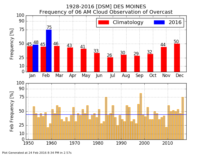
25 Feb 2016 05:35 AMSeeing clear skies, let alone sunshine has been a struggle this month. The featured chart displays the frequency of having overcast conditions reported by the Des Moines Airport weather station. The top chart displays the monthly climatology frequency along with those experienced this year. The bottom chart displays the February values for each year on record. This analysis places three quarters of the 6 AMs so far this month as being overcast and only 1998 was higher for the entire month. Maybe our luck this month will change with the four days we have left!
Voting:
Good: 20
Bad: 12
Abstain: 11
Tags: clouds
Gloomy at noon
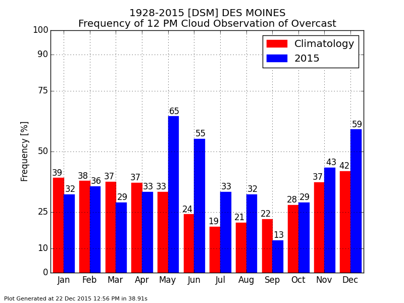
23 Dec 2015 05:41 AMWhile most days have seen warm temperatures this December, clouds have been common as well. The featured chart displays the frequency of having overcast conditions reported by the Des Moines Airport weather sensor for this year and over all the years by month. For this year, only May is shown at a higher frequency of having overcast conditions at noon. More gloomy conditions are in the forecast for the rest of the month.
Voting:
Good: 19
Bad: 9
Abstain: 9
Tags: clouds
Overcast and Temps
09 Dec 2015 05:36 AMEven with overcast sky conditions for much of Tuesday, temperatures were still able to warm into the low 50s for some locations in the state. Is this combination of clouds and warm temperatures typical for December? The featured chart displays the frequency of overcast conditions being reported by the Des Moines Airport by temperature for December. There are interesting things going on within the plot with a clear signal that overcast conditions as less likely as temperatures reach colder values below freezing. This makes sense was clouds help retain heat at night time, which prevents temperatures from cooling more rapidly.
Voting:
Good: 13
Bad: 8
Abstain: 4
Tags: clouds
Clouds and Temps
20 Jul 2015 05:36 AMThe presence of clouds has an impact on near surface air temperature, but that impact varies by time of day and time of year. The featured chart attempts to tease out the impact by looking at the simple difference between hours that have significant cloud cover versus all hourly temperature reports. A general summation of the chart is that clouds suppress temperatures during the daytime and support temperatures at night time. There is a day of the year impact as well with the largest differences occurring in the fall season.
Voting:
Good: 15
Bad: 4
Abstain: 5
Tags: clouds
Overcast at noon
22 Dec 2014 05:45 AMIf your impression is that it has been exceptionally cloudy this month, you are very perceptive! The featured chart displays the monthly frequency of having overcast clouds reported by the Des Moines Airport weather station at noon. The red bars represent the long term average while the blue bars are the frequencies for this year. This analysis shows 76% of the days this month being overcast at noon while the average is 42%. For this metric, December is the most cloudy month of the year, but it should not be this cloudy!
Voting:
Good: 11
Bad: 3
Abstain: 2
Tags: clouds
Clouds this December
11 Dec 2014 05:43 AMThe featured chart is an attempt to show automated cloud reports from the Des Moines Airport ASOS. These cloud reports include up to four levels of cloud coverage. Once the automated sensor reaches a cloud deck that it considers to be overcast, no further reports are possible above that layer. The past week has seen plenty of clouds with ceilings below five thousand feet. You can now generate this plot on the website for other sites the IEM collects data for and for previous months in the archive.
Voting:
Good: 12
Bad: 6
Abstain: 4
Tags: clouds
Clouds then Rain
09 Jul 2014 05:41 AMSkies were mostly fair on Tuesday with even the 4 AM observation reporting "clear" from the automated airport sensor in Des Moines. The featured chart looks at the frequency of having measurable precipitation for the midnight to 8 AM period the day following an hour with a given cloud coverage reported. In general, having overcast skies have more frequent rainfall events than clear skies which makes intuitive sense. Of course you have to have clouds for it to rain, so having overcast conditions later in the day leading up to the next day increases the frequency and having clear skies decreases the frequency. The overall frequency of having rainfall sometime during the 12-8 AM period in July is around 15%.
Voting:
Good: 8
Bad: 4
Abstain: 4
Tags: clouds jul
Influence of clouds
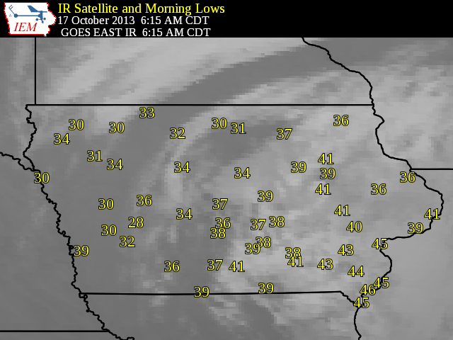
21 Oct 2013 05:36 AMThe featured map displays the combination of morning low temperatures and infrared satellite imagery for this past Thursday morning. The white areas on the map represent the presence of clouds and the warmest low temperatures you can find on the map are underneath these clouds. Clouds play a critical role in the radiation balance by absorbing long wave radiation emitted by the surface and then re-emitting it back toward the ground. This process helps keep air temperatures warmer versus nearby areas without clouds.
Voting:
Good: 23
Bad: 6
Tags: clouds
Clouds and Temperature
08 Nov 2012 04:28 AMThe past few days have seen mostly cloudy conditions here in Iowa. The noticeable visual effect for us is a lack of sunshine during the day and not seeing stars at night! Besides visual effects, clouds are an important component of the surface energy budget (which drives weather variables like near surface temperature). During the daylight, clouds reflect energy from the sun back out into space and act like a mirror. For all 24 hours of the day, clouds are absorbing and re-emitting energy from the ground back down to us, acting like a blanket. The featured image illustrates the effect of significant cloud cover by comparing hours with clouds against all available hours of observations from the Des Moines Airport sensor. The plot shows the primary effect of keeping temperatures cooler during the daytime and keeping temperatures comparatively warmer during the nighttime. The strongest effects are when solar heating of the ground is most efficient in the late summer / early fall season (drier/warmer soils, plenty of potential sunshine for surface heating) and during the early morning hours in spring and fall (peak radiational cooling due to lower humidities). Restating, these times are when clouds have the most influence. So while clouds have been helping to keep us recently cool during the daytime, they have kept overnight temperatures higher than they would be with clear skies at night.
Voting:
Good: 36
Bad: 7
Tags: clouds
Cloud Sensor Differences
30 Nov 2011 06:02 AMThe airport weather sensors for Des Moines and Ames are typically called 'ASOS' sensors and lumped into the same data pile as they both have similar sensors and maintenance standards. The featured chart presents a summary of reported sky conditions at 6 AM each morning this year. While these sites are only separated by 30 some miles, there are some large differences in the number of clear mornings reported. The difference here is that the Des Moines sensor has augmentors that report cloud ceilings higher (to 25,000 feet) in the sky than the Ames sensor can (to 12,000 feet). This is just one of the data quirks that keeps life fun and various people employed to keep track of this all!
Voting:
Good: 23
Bad: 5
Tags: clouds
Cool days and clear skies
08 Sep 2011 05:50 AMThe weather these past few days has been remarkable for cool high temperatures along with mostly clear skies overhead. The featured chart attempts to look at the relationship of having cool days along with mostly clear skies or northerly winds. While the determination of these two criteria was somewhat arbitrary, the signal appears to be reasonable. Having northerly winds is common for these cool days, but least important during the summer time when the air to our north may not be that cold. Clear skies are the least common during May and June, when are surface heating rates are the largest.
Voting:
Good: 8
Bad: 5
Tags: climate clouds highs
June Highs and Clouds
23 Jun 2011 05:55 AMHigh temperatures on Wednesday struggled in the 60s and were only a few degrees warmer than the coldest high temperatures on record for the date. This was thanks to a thick cloud cover and cold air brought in from our north. The featured chart looks at a measure of the amount of cloud cover on days were the high temperature was at record minimums and maximums. It makes intuitive sense that the coldest days are typically more cloudy during the spring, summer, and fall months as the sun is effective at warming the ground thanks to its high declination. Clouds are less important in the winter months as temperatures are dominated by organized air masses and the sun is less effective. For the warmest temperatures, having more sunny conditions are the most important in October it appears. Outside of a blip for warmest days in May, the plot has two clear annual signals!
Voting:
Good: 14
Bad: 5
Tags: highs climate clouds
Frequency of clouds
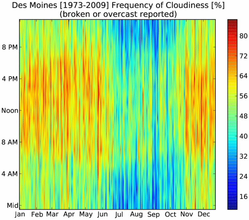
01 Oct 2010 05:47 AMThe featured chart presents the hourly frequency of cloudy or mostly cloudy skies by day of the year based on observation data at the Des Moines Airport. The plot has a number of interesting features about the diurnal and annual cycles in Iowa. Firstly, a good number of our clouds are a result of day time heating by the sun. The late summer and fall months show up nicely for having fewer clouds during the night time. The forecast for the next 5-7 days continues to keep most of the clouds away with very pleasant fall weather!
Voting:
Good: 68
Bad: 14
Tags: climate clouds
On a clear day
27 Aug 2010 05:57 AMOur stretch of sunny days looks to continue today. The featured chart looks at the observed frequencies of having one day (black line) and three days in a row (blue line) of mostly clear or clear skies as observed at the Des Moines Airport. The chart shows September as having the highest frequencies with an interesting dip in the trend during the middle of the month. It is not clear what would be causing that, but this is another chart that would indicate perhaps fall is the best season of the year in Iowa!
Voting:
Good: 57
Bad: 15
Tags: climate clouds
