Past IEM Features tagged: 2010
Another October streak
14 Oct 2011 05:56 AMOur past 12 days have seen daily high temperatures above climatology making for the longest streak this year. The featured chart presents the daily streaks above or below (negative numbers) for Ames since the beginning of last year. Last year also saw a long streak in October with highs above average. Our streak this year will end soon with reality setting back in. The bottom plot shows the streaks for low temperature and our warm nights in July certainly stick out.
Voting:
Good: 25
Bad: 10
Tags: 2010 2011
An extra foot
06 Jan 2011 05:51 AMYesterday's feature presented the last four years as being wetter than average statewide. The featured map compares these four years (2007-2010) against the 30 years previous to that. Please note that the units of this chart are inches per year, so a good portion of the state is shown with values in the 10-15 inches range. This means that the past four years have averaged 10-15 inches more per year than the average of the previous 30 years. Some portions of the state have not been as relatively wet and even a deficit appears in far northwestern Iowa.
Voting:
Good: 25
Bad: 2
Tags: precip 2007 2008 2009 2010
Months of 2010
04 Jan 2011 05:53 AMThe featured chart presents the monthly percentiles for total precipitation and average temperature for Ames and the areal averaged value for the state as unofficially computed by the IEM. The year was very wet and slightly cooler than average. October ended up being dry and warm, which was a huge help to get the crops harvested.
Voting:
Good: 18
Bad: 2
Tags: 2010
50 degree soils
29 Oct 2010 05:53 AMOur mostly sunny and mild October has helped keep 4 inch depth soil temperatures well above 50 degrees which is a key threshold used for fall nitrogen application in fields (temperatures need to be colder than 50 to make the application successful). Our recent stretch of cool weather has allowed temperatures to dip below 50 for the first time this fall and as is shown in the featured chart, this makes for the latest date in the fall season for the first sub 50 degree to have occured based on our data back to the mid 80s.
Voting:
Good: 59
Bad: 14
Tags: soil 2010
First Flakes of Fall
28 Oct 2010 05:52 AMThe first snow flakes of the season where reported yesterday afternoon over extreme northwest Iowa thanks to our large storm system to the north. The featured chart presents the first fall occurence of snow as reported by the sensors at the larger Iowa airports and the human COOP observers. The average first occurence is around the first of November, so yesterday's snow is nothing exceptional. The winds are finally expected to die down some this evening with the coldest night of the season on the way for tonight.
Voting:
Good: 44
Bad: 4
Tags: climate snow 2010
Above average humidity returns again
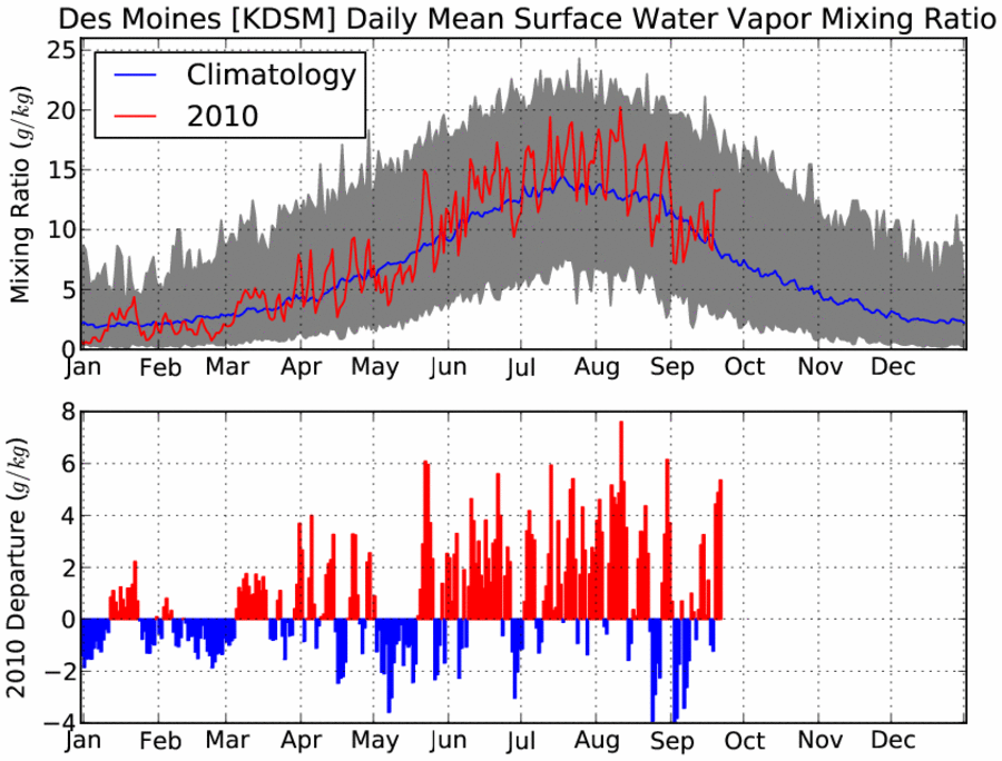
23 Sep 2010 05:02 AMA push of warm and moist air has once again invaded the state making today feel more like summer than fall. The featured chart presents the climatology of near surface water vapor mixing ratio, which is a measure of the amount of moisture held in the atmosphere. The summer of 2010 has certainly seen more than its fair share of humidity as noted by the dominance of red in the lower plot. The grey filled area in the top plot represents the range of mixing ratio. It is interesting to see that the lowest values in the summer are still higher than the maxes in the winter.
Voting:
Good: 25
Bad: 8
Tags: dewpoint 2010 climate
Too many of these events
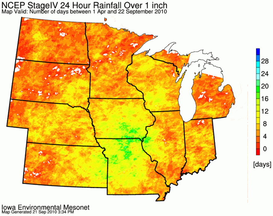
22 Sep 2010 05:55 AMAnd yet another round of heavy rain producing storms dumped well over an inch over parts of Southern Iowa yesterday. The featured map presents the number of 1+ inch rainfall events over 24 hours since the first of April. A good portion of southern Iowa is shown in the 20 day range. The plot nicely shows the areas that have seen flooding this year. More of these events are in the forecast for this week.
Voting:
Good: 31
Bad: 6
Tags: 2010
30 degree jumps
21 Sep 2010 05:59 AMAfter having high temperatures in the 50s on Sunday, warm air rushed the state on Monday pushing highs well into the 80s. For some places like Ames, the jump in high temperature was over 30 degrees in just one day! The featured chart presents the largest one day high temperature rise and drop along with the number of occurences of a 30+ degree change based on data for Ames. You can see in the summertime that these large of changes do not occur and are rare for September.
Voting:
Good: 36
Bad: 8
Tags: high 2010
Streak above 70 ends
17 Sep 2010 05:54 AMThe high temperature for Ames yesterday failed to top 70 degrees, which was the first time since mid May it happened. The featured chart presents the longest streaks for Ames having the high temperature at or above 70. This year comes in 9th all-time. The forecast has highs back into the 80s next week.
Voting:
Good: 39
Bad: 10
Tags: 2010
Watching more than Texas
16 Sep 2010 05:56 AMThe Storm Prediction Center issued another watch for Iowa yesterday making for the 113th watch issued this year that covered portions of Iowa. The featured graph displays the number of watches year to date issued for Iowa and Texas. This is the first year since 1997 that Iowa has seen more watches. The bottom graph displays the percentage of all watches issued that cover a portion of Iowa. This year has seen the highest percentage! Another reason why 2010 has been an exceptional year.
Voting:
Good: 33
Bad: 5
Tags: 2010 spc
Peak intensities
08 Sep 2010 05:55 AMThe featured graph presents IEM computed peak rainfall accumulations measured over an hour and two hours. The values are actual totals from the ASOS precipitation sensor. Just over a week ago, the Ames sensor reported 3.52 inches of rain over a two hour period. This value is only topped on the chart by Spencer back in 2005. You may notice that the two hour total is no where near doubling the one hour total. In Iowa, the heaviest of rainfall events will only last 30 minutes or so. It takes training of multiple cells to produce these large totals.
Voting:
Good: 27
Bad: 7
Tags: 2010 precip
No lack of GDDs this year
07 Sep 2010 05:52 AMWhile this growing season has not be overly hot as measured by high temperature, our overnight low temperatures have been well above average. The featured map displays the percentile for growing degree days since 1 May (a value of 100 implies the largest accumulation on record for the site). Most of the state is shown in the 80-90+ percentile. The result is the corn and soybean crops are well ahead of schedule this year.
Voting:
Good: 37
Bad: 7
Tags: 2010
Lows above average
04 Sep 2010 06:44 AMThe featured chart presents the number of days during the meteorological summer (June - August) that either the high or low temperature were above average. The average used was the current standard climate (1971-2000). For 2010, 74 out of the 92 days were above average for low temperature which is easily the largest value on this chart for low temperature. The colors represent if the value was above 46 or below. The 1930s stand out for being warm while the 1960s for being cool.
Voting:
Good: 48
Bad: 12
Tags: 2010 summer
Blew a big lead
01 Sep 2010 06:00 AMFor Des Moines, the summer of 2010 came so close to breaking the record for precipitation. The featured chart shows that for most of the summer, 2010 had a sizable lead over the hallowed 1993. With just three days to go, 1993 overtook this year and barely held on to win by just 7 hundredths of an inch! Heavy rainfall once again visited the state last night, but it was not quite enough for Des Moines.
Voting:
Good: 30
Bad: 10
Tags: 2010
As windy as it has been all summer
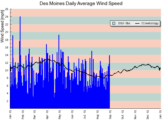
31 Aug 2010 06:00 AMSustained wind speeds on Monday were some of the strongest we have seen since early May as shown by the featured image. The black line represents climatology and nicely shows the yearly minimum in winds during the early part of August. Wind speeds will increase as surface temperature gradients become stronger during the spring and fall seasons. Thunderstorms are back visiting the state this morning with more expected into Thursday.
Voting:
Good: 22
Bad: 7
Tags: 2010 wind
Sub 60s set to return
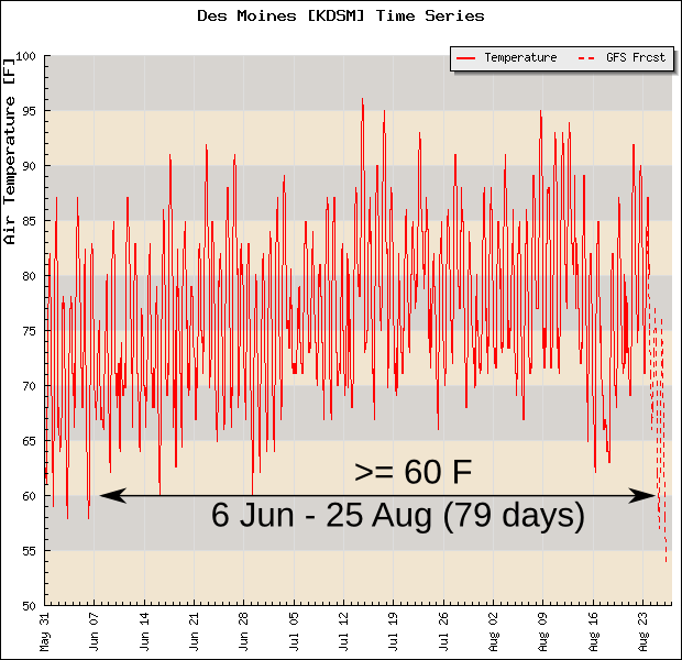
24 Aug 2010 05:00 AMIt has been a long and muggy summer. For Des Moines, the temperature has been at or above 60 degrees since the 6th of June. This is the second longest streak of days behind 81 days back in 1983. A front is sweeping the state clean of muggy air this morning and will usher in very comfortable and much drier air for mid August. The featured image shows a model forecast of air temperatures with values expected to drop below 60 on Wednesday which will end the streak at 79 days.
Voting:
Good: 27
Bad: 4
Tags: 2010
Record rainfall
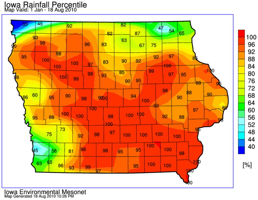
19 Aug 2010 06:12 AMThe featured map displays IEM calculated precipitation percentiles for the year to date period. Much of the state is shown near 100, which implies that the rainfall total this year is the highest on record. Three corners of the state have not seen near record values according to this analysis with some locations even below average (less than 50).
Voting:
Good: 28
Bad: 5
Tags: 2010
2010 Severe Weather Events
30 Jul 2010 06:09 AMThe featured map displays an IEM computed statistic of how many severe weather events by NWS Forecast Office there have been so far this year. An event is a day where an office issued at least 5 severe or tornado warnings. Places like North Dakota have seen an active year compared with most of Texas and Florida. Some severe weather is possible today along with heavy rainfall.
Voting:
Good: 32
Bad: 10
Tags: 2010
Extreme Dewpoints
16 Jul 2010 05:13 AMThe featured map displays maximum observed dewpoints on this past Wednesday. Observation sites in both the ASOS and AWOS networks reported dewpoints in the lower 80s, which is a rare event. Dewpoint values just in the lower 70s are considered dangerous! A front was able to sweep the state clean of this obscene air for now, but there is plenty of time in summer left for it to return.
Voting:
Good: 72
Bad: 12
Tags: dewpoint 2010
Uncomfortable Days
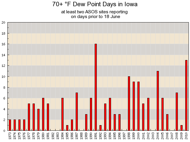
18 Jun 2010 06:08 AMHeat and humidity returned to Iowa on Thursday with most of the state experiencing dew point temperatures in the lower 70s. The featured chart presents the number of days per year that at least two ASOS sites in the state report a 70+ dew point on the same day prior to 18 June. This year has already seen 13 days, which is the second highest total since 1973. Another uncomfortable day is in store for today.
Voting:
Good: 46
Bad: 153
Tags: dewpoint 2010
Some deficits
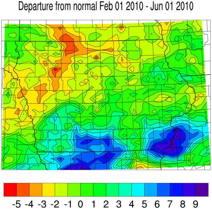
03 Jun 2010 05:11 AMThe featured map is an IEM analysis of precipitation departures from average for the past 4 months. Values (shown in inches) range from being 7-8 above to 4-5 below average for this period. Our most recent heavy rain event didn't help the areas shown with deficits, but the weather models hint that the next storm system arriving on Friday may bring heavy rain for northern Iowa.
Voting:
Good: 25
Bad: 8
Tags: 2010
Lack of tornados
28 May 2010 05:28 AMThe featured map displays a summary of preliminary tornado reports so far for this year. A close inspection shows no dots in Iowa, which is the first time since 1980 that Iowa has yet to see a tornado this far into the year. The forecast does not indicate significant tornado chances for the state for the next week.
Voting:
Good: 94
Bad: 18
Tags: 2010
Yesterday was hot
25 May 2010 05:10 AMTemperatures soared into the lower 90s on Monday and are expected to approach 90 again today. The featured map provides an analysis of the percentile value for the warmest temperature so far this year versus historical data prior to 25 May. Values of 100 imply that the warmest temperature this year is warmer than any temperature in previous years prior to 25 May. Thunderstorms are expected to today with slightly cooler weather tomorrow.
Voting:
Good: 22
Bad: 6
Tags: 2010
Only a few swings this year
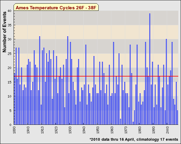
16 Apr 2010 05:07 AMThe featured chart displays the IEM computed number of temperature swings during the springtime season between 26 and 38 degrees. The algorithm counts the number of times the temperature exceeded 38 degrees and then was cooler than 26 degrees. You might consider these as freeze and thaw cycles. Anyway, for 2010 we have seen very few of these temperature swings (just 5 in fact) while the long term average value is around 17. We have warmed up and have not looked back!
Voting:
Good: 33
Bad: 30
Tags: 2010
Warm 3 weeks
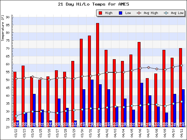
12 Apr 2010 05:08 AMThe past 21 days have seen the daily high temperature at or above 50 degrees for Ames. For the period, this is the first time it has happened since 1986! Warm weather looks to continue this week with no return to winter in immediate sight. Could we really go from winter to spring to summer without a relapse back into winter?
Voting:
Good: 25
Bad: 8
Tags: 2010
Upsidedown looking plot
29 Mar 2010 05:07 AMThe featured plot displays the percentile value of the warmest temperature reported so far this year versus previous years for the period up to 29 March. While some places in northwestern Iowa have yet to see 60+ degrees, the most abnormally coldest temperatures have been in southwestern Iowa. The highest percentiles (warmest compared with local climatology) are in northeastern Iowa. The forecast for this week will rearrange this plot with much of the state in the 70s! Hello springtime!
Voting:
Good: 22
Bad: 8
Tags: 2010
Frozen 2010
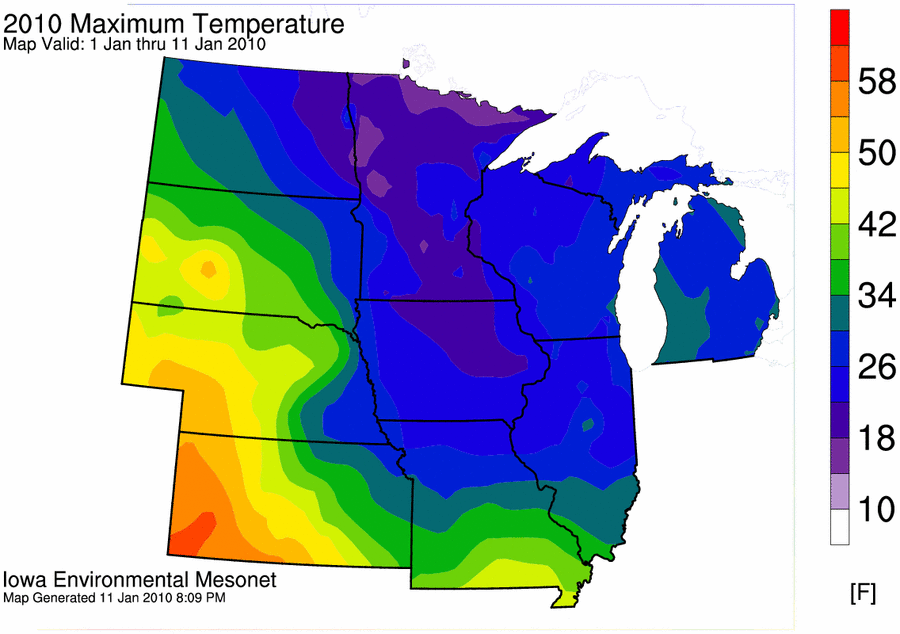
12 Jan 2010 06:10 AMThe featured map is an analysis of the maximum temperature reported so far this year with most locations in the Midwest below freezing. The forecast does hold hope for warmer air and some above freezing temperatures starting Wednesday!
Voting:
Good: 22
Bad: 3
Tags: 2010


