National Weather Service Raw Text Product
Displaying AFOS PIL: RTPIA Received: 2024-04-24 00:54 UTC
Previous in Time Latest Product Next in Time
View All KDMX Products for 24 Apr 2024 View All RTP Products for 24 Apr 2024 View As Image Download As Text
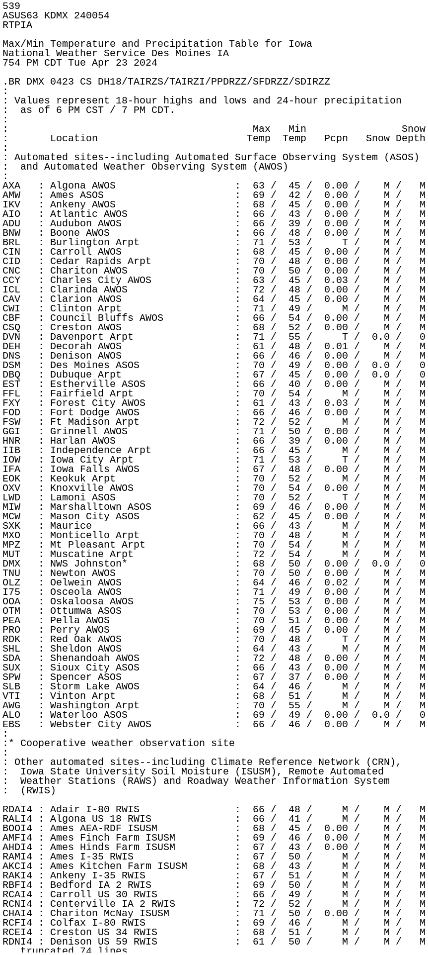
539
ASUS63 KDMX 240054
RTPIA

Max/Min Temperature and Precipitation Table for Iowa
National Weather Service Des Moines IA
754 PM CDT Tue Apr 23 2024

.BR DMX 0423 CS DH18/TAIRZS/TAIRZI/PPDRZZ/SFDRZZ/SDIRZZ
:
: Values represent 18-hour highs and lows and 24-hour precipitation
:  as of 6 PM CST / 7 PM CDT.
:
:                                         Max   Min                Snow
:       Location                         Temp  Temp   Pcpn   Snow Depth
:
: Automated sites--including Automated Surface Observing System (ASOS)
:  and Automated Weather Observing System (AWOS)
:
AXA   : Algona AWOS                    :  63 /  45 /  0.00 /    M /   M
AMW   : Ames ASOS                      :  69 /  42 /  0.00 /    M /   M
IKV   : Ankeny AWOS                    :  68 /  45 /  0.00 /    M /   M
AIO   : Atlantic AWOS                  :  66 /  43 /  0.00 /    M /   M
ADU   : Audubon AWOS                   :  66 /  39 /  0.00 /    M /   M
BNW   : Boone AWOS                     :  66 /  48 /  0.00 /    M /   M
BRL   : Burlington Arpt                :  71 /  53 /     T /    M /   M
CIN   : Carroll AWOS                   :  68 /  45 /  0.00 /    M /   M
CID   : Cedar Rapids Arpt              :  70 /  48 /  0.00 /    M /   M
CNC   : Chariton AWOS                  :  70 /  50 /  0.00 /    M /   M
CCY   : Charles City AWOS              :  63 /  45 /  0.03 /    M /   M
ICL   : Clarinda AWOS                  :  72 /  48 /  0.00 /    M /   M
CAV   : Clarion AWOS                   :  64 /  45 /  0.00 /    M /   M
CWI   : Clinton Arpt                   :  71 /  49 /     M /    M /   M
CBF   : Council Bluffs AWOS            :  66 /  54 /  0.00 /    M /   M
CSQ   : Creston AWOS                   :  68 /  52 /  0.00 /    M /   M
DVN   : Davenport Arpt                 :  71 /  55 /     T /  0.0 /   0
DEH   : Decorah AWOS                   :  61 /  48 /  0.01 /    M /   M
DNS   : Denison AWOS                   :  66 /  46 /  0.00 /    M /   M
DSM   : Des Moines ASOS                :  70 /  49 /  0.00 /  0.0 /   0
DBQ   : Dubuque Arpt                   :  67 /  45 /  0.00 /  0.0 /   0
EST   : Estherville ASOS               :  66 /  40 /  0.00 /    M /   M
FFL   : Fairfield Arpt                 :  70 /  54 /     M /    M /   M
FXY   : Forest City AWOS               :  61 /  43 /  0.03 /    M /   M
FOD   : Fort Dodge AWOS                :  66 /  46 /  0.00 /    M /   M
FSW   : Ft Madison Arpt                :  72 /  52 /     M /    M /   M
GGI   : Grinnell AWOS                  :  71 /  50 /  0.00 /    M /   M
HNR   : Harlan AWOS                    :  66 /  39 /  0.00 /    M /   M
IIB   : Independence Arpt              :  66 /  45 /     M /    M /   M
IOW   : Iowa City Arpt                 :  71 /  53 /     T /    M /   M
IFA   : Iowa Falls AWOS                :  67 /  48 /  0.00 /    M /   M
EOK   : Keokuk Arpt                    :  70 /  52 /     M /    M /   M
OXV   : Knoxville AWOS                 :  70 /  54 /  0.00 /    M /   M
LWD   : Lamoni ASOS                    :  70 /  52 /     T /    M /   M
MIW   : Marshalltown ASOS              :  69 /  46 /  0.00 /    M /   M
MCW   : Mason City ASOS                :  62 /  45 /  0.00 /    M /   M
SXK   : Maurice                        :  66 /  43 /     M /    M /   M
MXO   : Monticello Arpt                :  70 /  48 /     M /    M /   M
MPZ   : Mt Pleasant Arpt               :  70 /  54 /     M /    M /   M
MUT   : Muscatine Arpt                 :  72 /  54 /     M /    M /   M
DMX   : NWS Johnston*                  :  68 /  50 /  0.00 /  0.0 /   0
TNU   : Newton AWOS                    :  70 /  50 /  0.00 /    M /   M
OLZ   : Oelwein AWOS                   :  64 /  46 /  0.02 /    M /   M
I75   : Osceola AWOS                   :  71 /  49 /  0.00 /    M /   M
OOA   : Oskaloosa AWOS                 :  75 /  53 /  0.00 /    M /   M
OTM   : Ottumwa ASOS                   :  70 /  53 /  0.00 /    M /   M
PEA   : Pella AWOS                     :  70 /  51 /  0.00 /    M /   M
PRO   : Perry AWOS                     :  69 /  45 /  0.00 /    M /   M
RDK   : Red Oak AWOS                   :  70 /  48 /     T /    M /   M
SHL   : Sheldon AWOS                   :  64 /  43 /     M /    M /   M
SDA   : Shenandoah AWOS                :  72 /  48 /  0.00 /    M /   M
SUX   : Sioux City ASOS                :  66 /  43 /  0.00 /    M /   M
SPW   : Spencer ASOS                   :  67 /  37 /  0.00 /    M /   M
SLB   : Storm Lake AWOS                :  64 /  46 /     M /    M /   M
VTI   : Vinton Arpt                    :  68 /  51 /     M /    M /   M
AWG   : Washington Arpt                :  70 /  55 /     M /    M /   M
ALO   : Waterloo ASOS                  :  69 /  49 /  0.00 /  0.0 /   0
EBS   : Webster City AWOS              :  66 /  46 /  0.00 /    M /   M
:
:* Cooperative weather observation site
:
: Other automated sites--including Climate Reference Network (CRN),
:  Iowa State University Soil Moisture (ISUSM), Remote Automated
:  Weather Stations (RAWS) and Roadway Weather Information System
:  (RWIS)

RDAI4 : Adair I-80 RWIS                :  66 /  48 /     M /    M /   M
RALI4 : Algona US 18 RWIS              :  66 /  41 /     M /    M /   M
BOOI4 : Ames AEA-RDF ISUSM             :  68 /  45 /  0.00 /    M /   M
AMFI4 : Ames Finch Farm ISUSM          :  69 /  46 /  0.00 /    M /   M
AHDI4 : Ames Hinds Farm ISUSM          :  67 /  43 /  0.00 /    M /   M
RAMI4 : Ames I-35 RWIS                 :  67 /  50 /     M /    M /   M
AKCI4 : Ames Kitchen Farm ISUSM        :  68 /  43 /     M /    M /   M
RAKI4 : Ankeny I-35 RWIS               :  67 /  51 /     M /    M /   M
RBFI4 : Bedford IA 2 RWIS              :  69 /  50 /     M /    M /   M
RCAI4 : Carroll US 30 RWIS             :  66 /  49 /     M /    M /   M
RCNI4 : Centerville IA 2 RWIS          :  72 /  52 /     M /    M /   M
CHAI4 : Chariton McNay ISUSM           :  71 /  50 /  0.00 /    M /   M
RCFI4 : Colfax I-80 RWIS               :  69 /  46 /     M /    M /   M
RCEI4 : Creston US 34 RWIS             :  68 /  51 /     M /    M /   M
RDNI4 : Denison US 59 RWIS             :  61 /  50 /     M /    M /   M
RDSI4 : Des Moines I-35 RWIS           :  67 /  48 /     M /    M /   M
RDMI4 : Des Moines I-235 RWIS          :  70 /  53 /     M /    M /   M
ERYI4 : Early US 20/US 71 RWIS         :  63 /  51 /     M /    M /   M
RDYI4 : Eddyville IA 137 RWIS          :  71 /  55 /     M /    M /   M
RETI4 : Estherville Hwy 9 RWIS         :  63 /  44 /     M /    M /   M
RFDI4 : Fort Dodge US 20 RWIS          :  66 /  47 /     M /    M /   M
RGAI4 : Granger IA 141 RWIS            :  68 /  47 /     M /    M /   M
GREI4 : Greenfield Neely Kinyon ISUSM  :  68 /  50 /  0.00 /    M /   M
RGRI4 : Grinnell I-80 RWIS             :  67 /  49 /     M /    M /   M
RHAI4 : Hanlontown I-35 RWIS           :  62 /  43 /     M /    M /   M
DOCI4 : Jefferson Deals Orchard ISUSM  :  68 /  61 /  0.00 /    M /   M
RJFI4 : Jefferson IA 4 RWIS            :  68 /  45 /     M /    M /   M
KNAI4 : Kanawha ISUSM                  :  64 /  40 /  0.00 /    M /   M
RLEI4 : Leon IA 2 RWIS                 :  71 /  52 /     M /    M /   M
SSFI4 : Lucas/Stephens SF RAWS         :  72 /  52 /  0.00 /    M /   M
RMTI4 : Marshalltown US 30 RWIS        :  68 /  48 /     M /    M /   M
RMCI4 : Mason City I-35 RWIS           :  61 /  46 /     M /    M /   M
NSSI4 : Neal Smith NWR CRN             :  68 /  48 /  0.00 /    M /   M
NSWI4 : Neal Smith NWR RAWS            :  70 /  50 /  0.00 /    M /   M
ROSI4 : Osceola I-35 RWIS              :  70 /  52 /     M /    M /   M
OSTI4 : Oskaloosa Tassel Ridge ISUSM   :  70 /  54 /  0.00 /    M /   M
ROTI4 : Ottumwa US 63 RWIS             :  71 /  56 /     M /    M /   M
RPFI4 : Plainfield US 218 RWIS         :  64 /  49 /     M /    M /   M
RRWI4 : Rockwell City US 20/IA 4 RWIS  :  66 /  46 /     M /    M /   M
RSBI4 : Steamboat Rock US 20 RWIS      :  66 /  49 /     M /    M /   M
RWLI4 : Waterloo US 20 RWIS            :  66 /  50 /     M /    M /   M
RWII4 : Williams I-35 RWIS             :  65 /  46 /     M /    M /   M
.END

.BR DMX 0423 C DH18/TAIRZX/TAIRZN/PPDRZZ/SFDRZZ/SDIRZZ
:
: Values represent the past 24 hours ending around 6 PM.
:
:                                 Time    Max   Min                Snow
:      Location                 DDHHMM   Temp  Temp   Pcpn   Snow Depth
:
: Cooperative observer and other sites
:
CRPI4 : Cedar Rapids No 1   : DD231700 /  69 /  50 /  0.00 /  0.0 /   0
DVNI4 : Davenport WFO       : DD231900 /   M /   M /     M /    M /   0
DCRI4 : Decorah             : DD231900 /  67 /  43 /  0.03 /  0.0 /   0
GRNI4 : Greenfield          : DD231900 /   M /   M /  0.00 /    M /   M
PGHI4 : PRIMGHAR            : DD231600 /  69 /  43 /  0.00 /  0.0 /   0
STYI4 : Story City          : DD231900 /   M /   M /  0.00 /    M /   M
.END

.BR DMX 0423 C DH18/GDIRZZ/GTIRZZ
:
: ...Frost Depth...
:
: This information is normally provided during the cool season. The
:  most recent information is provided for each location. The date and
:  time of each observation are in Central Time. Note that the
:  observation may not be from the current day. Frost Depth refers to
:  the depth of frost penetration into the ground, in inches. Frost Top
:  refers to the depth of the top of the frost layer in inches. A value
:  of zero means frost exists from the ground surface to the frost
:  depth.
:
:                                Date/Time  Frost  Frost
:      Location                     DDHHMM  Depth    Top
:
: Cooperative observer and other sites
:
ARX   : La Crosse WFO       : DY2404220700 /    0 /    M
.END

These data are preliminary and have not undergone final quality
control /QC/ by NCEI. Therefore, these data are subject to revision.
Final and certified climate data can be accessed at the National
Centers for Environmental Information /NCEI/ - www.ncei.noaa.gov .

$$