National Weather Service Raw Text Product
Displaying AFOS PIL: RTPDDC Received: 2024-09-22 12:08 UTC
Previous in Time Latest Product Next in Time
View All KDDC Products for 22 Sep 2024 View All RTP Products for 22 Sep 2024 View As Image Download As Text
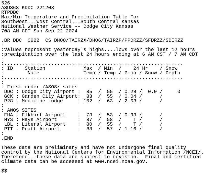
526
ASUS63 KDDC 221208
RTPDDC
Max/Min Temperature and Precipitation Table For
Southwest...West Central...South Central Kansas
National Weather Service -- Dodge City Kansas
708 AM CDT Sun Sep 22 2024

.BR DDC  0922  CS DH00/TAIRZX/DH06/TAIRZP/PPDRZZ/SFDRZZ/SDIRZZ
:
:Values represent yesterday's highs....lows over the last 12 hours
:precipitation over the last 24 hours ending at 6 AM CST / 7 AM CDT
:
:.............................................................
: ID    Station             Max  / Min  /    24 Hr    / Snow
:        Name               Temp / Temp / Pcpn / Snow / Depth
:.............................................................
:
: First order /ASOS/ sites
 DDC : Dodge City Airport :  85  /  55  / 0.29 /  0.0 /     0
 GCK : Garden City Airport:  83  /  55  / 0.04 /      /
 P28 : Medicine Lodge     : 102  /  63  / 2.03 /      /
:
: AWOS SITES
 EHA : Elkhart Airport    :  73  /  53  / 0.93 /      /
 HYS : Hays Airport       :  87  /  58  /    T /      /
 LBL : Liberal Airport    :  80  /  55  /    T /      /
 PTT : Pratt Airport      :  88  /  57  / 1.16 /      /
:
.END

These data are preliminary and have not undergone final quality
control by the National Centers for Environmental Information /NCEI/.
Therefore...these data are subject to revision.  Final and certified
climate data can be accessed at www.ncei.noaa.gov.

$$