National Weather Service Raw Text Product
Displaying AFOS PIL: RTPICT Received: 2024-09-19 12:31 UTC
Previous in Time Latest Product Next in Time
View All KICT Products for 19 Sep 2024 View All RTP Products for 19 Sep 2024 View As Image Download As Text
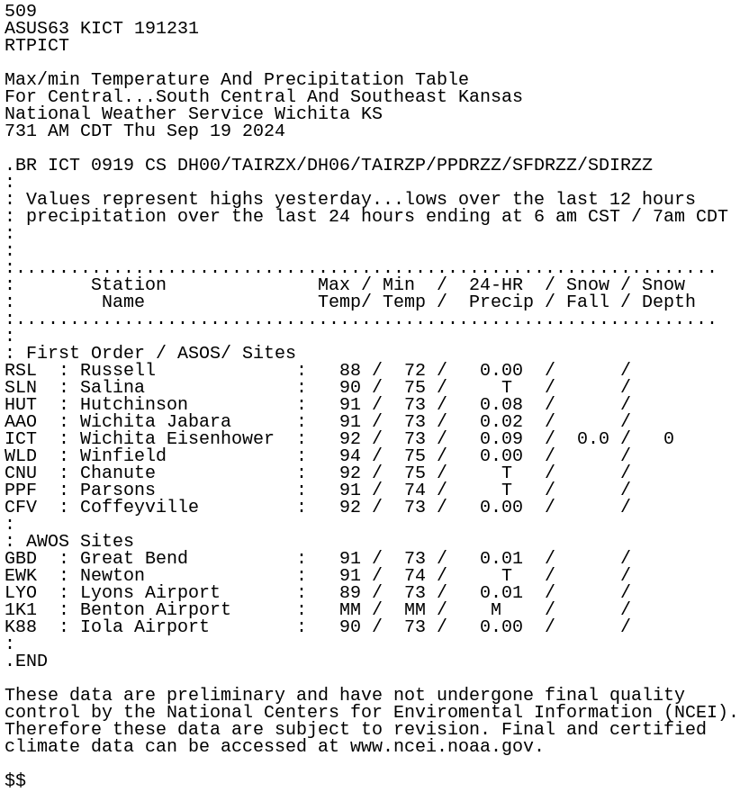
509
ASUS63 KICT 191231
RTPICT

Max/min Temperature And Precipitation Table
For Central...South Central And Southeast Kansas
National Weather Service Wichita KS
731 AM CDT Thu Sep 19 2024

.BR ICT 0919 CS DH00/TAIRZX/DH06/TAIRZP/PPDRZZ/SFDRZZ/SDIRZZ
:
: Values represent highs yesterday...lows over the last 12 hours
: precipitation over the last 24 hours ending at 6 am CST / 7am CDT
:
:
:.................................................................
:       Station              Max / Min  /  24-HR  / Snow / Snow
:        Name                Temp/ Temp /  Precip / Fall / Depth
:.................................................................
:
: First Order / ASOS/ Sites
RSL  : Russell             :   88 /  72 /   0.00  /      /
SLN  : Salina              :   90 /  75 /     T   /      /
HUT  : Hutchinson          :   91 /  73 /   0.08  /      /
AAO  : Wichita Jabara      :   91 /  73 /   0.02  /      /
ICT  : Wichita Eisenhower  :   92 /  73 /   0.09  /  0.0 /   0
WLD  : Winfield            :   94 /  75 /   0.00  /      /
CNU  : Chanute             :   92 /  75 /     T   /      /
PPF  : Parsons             :   91 /  74 /     T   /      /
CFV  : Coffeyville         :   92 /  73 /   0.00  /      /
:
: AWOS Sites
GBD  : Great Bend          :   91 /  73 /   0.01  /      /
EWK  : Newton              :   91 /  74 /     T   /      /
LYO  : Lyons Airport       :   89 /  73 /   0.01  /      /
1K1  : Benton Airport      :   MM /  MM /    M    /      /
K88  : Iola Airport        :   90 /  73 /   0.00  /      /
:
.END

These data are preliminary and have not undergone final quality
control by the National Centers for Enviromental Information (NCEI).
Therefore these data are subject to revision. Final and certified
climate data can be accessed at www.ncei.noaa.gov.

$$