National Weather Service Raw Text Product
Displaying AFOS PIL: RTPFSD Received: 2024-09-20 14:15 UTC
Previous in Time Latest Product Next in Time
View All KFSD Products for 20 Sep 2024 View All RTP Products for 20 Sep 2024 View As Image Download As Text
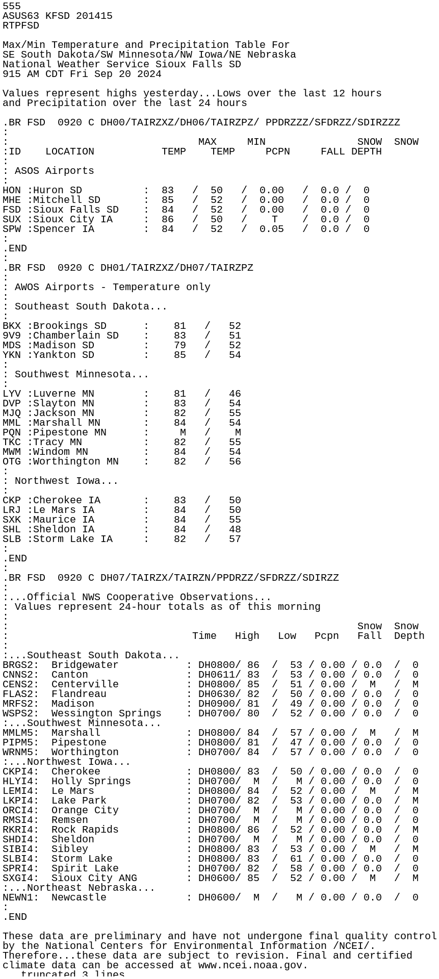
555
ASUS63 KFSD 201415
RTPFSD

Max/Min Temperature and Precipitation Table For
SE South Dakota/SW Minnesota/NW Iowa/NE Nebraska
National Weather Service Sioux Falls SD
915 AM CDT Fri Sep 20 2024

Values represent highs yesterday...Lows over the last 12 hours
and Precipitation over the last 24 hours

.BR FSD  0920 C DH00/TAIRZXZ/DH06/TAIRZPZ/ PPDRZZZ/SFDRZZ/SDIRZZZ
:
:                               MAX     MIN               SNOW  SNOW
:ID    LOCATION           TEMP    TEMP     PCPN     FALL DEPTH
:
: ASOS Airports
:
HON :Huron SD          :  83   /  50   /  0.00   /  0.0 /  0
MHE :Mitchell SD       :  85   /  52   /  0.00   /  0.0 /  0
FSD :Sioux Falls SD    :  84   /  52   /  0.00   /  0.0 /  0
SUX :Sioux City IA     :  86   /  50   /    T    /  0.0 /  0
SPW :Spencer IA        :  84   /  52   /  0.05   /  0.0 /  0
:
.END
:
.BR FSD  0920 C DH01/TAIRZXZ/DH07/TAIRZPZ
:
: AWOS Airports - Temperature only
:
: Southeast South Dakota...
:
BKX :Brookings SD      :    81   /   52
9V9 :Chamberlain SD    :    83   /   51
MDS :Madison SD        :    79   /   52
YKN :Yankton SD        :    85   /   54
:
: Southwest Minnesota...
:
LYV :Luverne MN        :    81   /   46
DVP :Slayton MN        :    83   /   54
MJQ :Jackson MN        :    82   /   55
MML :Marshall MN       :    84   /   54
PQN :Pipestone MN      :     M   /    M
TKC :Tracy MN          :    82   /   55
MWM :Windom MN         :    84   /   54
OTG :Worthington MN    :    82   /   56
:
: Northwest Iowa...
:
CKP :Cherokee IA       :    83   /   50
LRJ :Le Mars IA        :    84   /   50
SXK :Maurice IA        :    84   /   55
SHL :Sheldon IA        :    84   /   48
SLB :Storm Lake IA     :    82   /   57
:
.END
:
.BR FSD  0920 C DH07/TAIRZX/TAIRZN/PPDRZZ/SFDRZZ/SDIRZZ
:
:...Official NWS Cooperative Observations...
: Values represent 24-hour totals as of this morning
:
:                                                         Snow  Snow
:                              Time   High   Low   Pcpn   Fall  Depth
:
:...Southeast South Dakota...
BRGS2:  Bridgewater           : DH0800/ 86  /  53 / 0.00 / 0.0  /  0
CNNS2:  Canton                : DH0611/ 83  /  53 / 0.00 / 0.0  /  0
CENS2:  Centerville           : DH0800/ 85  /  51 / 0.00 /  M   /  M
FLAS2:  Flandreau             : DH0630/ 82  /  50 / 0.00 / 0.0  /  0
MRFS2:  Madison               : DH0900/ 81  /  49 / 0.00 / 0.0  /  0
WSPS2:  Wessington Springs    : DH0700/ 80  /  52 / 0.00 / 0.0  /  0
:...Southwest Minnesota...
MMLM5:  Marshall              : DH0800/ 84  /  57 / 0.00 /  M   /  M
PIPM5:  Pipestone             : DH0800/ 81  /  47 / 0.00 / 0.0  /  0
WRNM5:  Worthington           : DH0700/ 84  /  57 / 0.00 / 0.0  /  0
:...Northwest Iowa...
CKPI4:  Cherokee              : DH0800/ 83  /  50 / 0.00 / 0.0  /  0
HLYI4:  Holly Springs         : DH0700/  M  /   M / 0.00 / 0.0  /  0
LEMI4:  Le Mars               : DH0800/ 84  /  52 / 0.00 /  M   /  M
LKPI4:  Lake Park             : DH0700/ 82  /  53 / 0.00 / 0.0  /  M
ORCI4:  Orange City           : DH0700/  M  /   M / 0.00 / 0.0  /  0
RMSI4:  Remsen                : DH0700/  M  /   M / 0.00 / 0.0  /  0
RKRI4:  Rock Rapids           : DH0800/ 86  /  52 / 0.00 / 0.0  /  M
SHDI4:  Sheldon               : DH0700/  M  /   M / 0.00 / 0.0  /  0
SIBI4:  Sibley                : DH0800/ 83  /  53 / 0.00 /  M   /  M
SLBI4:  Storm Lake            : DH0800/ 83  /  61 / 0.00 / 0.0  /  0
SPRI4:  Spirit Lake           : DH0700/ 82  /  58 / 0.00 / 0.0  /  0
SXGI4:  Sioux City ANG        : DH0600/ 85  /  52 / 0.00 /  M   /  M
:...Northeast Nebraska...
NEWN1:  Newcastle             : DH0600/  M  /   M / 0.00 / 0.0  /  0
:
.END

These data are preliminary and have not undergone final quality control
by the National Centers for Environmental Information /NCEI/.
Therefore...these data are subject to revision. Final and certified
climate data can be accessed at www.ncei.noaa.gov.

$$